You are here: Home > Network List > TA - USArray Transportable Network (new EarthScope stations) Stations List
> Station O18K Koktuh Hills, AK, USA > Earthquake Result Viewer
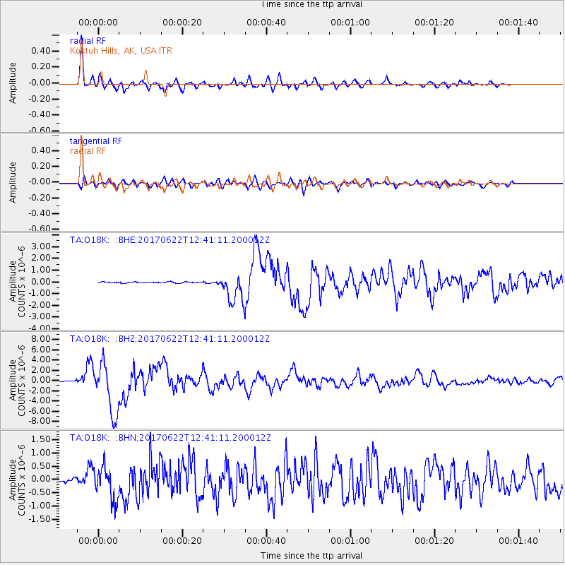
O18K Koktuh Hills, AK, USA - Earthquake Result Viewer
*The percent match for this event was below the threshold and hence no stack was calculated.
| Earthquake location: |
Near Coast Of Guatemala |
| Earthquake latitude/longitude: |
13.7/-91.1 |
| Earthquake time(UTC): |
2017/06/22 (173) 12:31:04 GMT |
| Earthquake Depth: |
10 km |
| Earthquake Magnitude: |
6.8 Mi |
| Earthquake Catalog/Contributor: |
NEIC PDE/at |
|
| Network: |
TA USArray Transportable Network (new EarthScope stations) |
| Station: |
O18K Koktuh Hills, AK, USA |
| Lat/Lon: |
59.85 N/155.21 W |
| Elevation: |
544 m |
|
| Distance: |
65.3 deg |
| Az: |
330.022 deg |
| Baz: |
105.811 deg |
| Ray Param: |
$rayparam |
*The percent match for this event was below the threshold and hence was not used in the summary stack. |
|
| Radial Match: |
92.99946 % |
| Radial Bump: |
348 |
| Transverse Match: |
79.718605 % |
| Transverse Bump: |
400 |
| SOD ConfigId: |
13570011 |
| Insert Time: |
2019-04-28 06:18:00.567 +0000 |
| GWidth: |
2.5 |
| Max Bumps: |
400 |
| Tol: |
0.001 |
|
Signal To Noise
| Channel | StoN | STA | LTA |
| TA:O18K: :BHZ:20170622T12:41:11.200012Z | 69.91428 | 5.0642643E-6 | 7.2435334E-8 |
| TA:O18K: :BHN:20170622T12:41:11.200012Z | 9.80607 | 6.339162E-7 | 6.4645285E-8 |
| TA:O18K: :BHE:20170622T12:41:11.200012Z | 41.25236 | 2.1868914E-6 | 5.3012513E-8 |
| Arrivals |
| Ps | |
| PpPs | |
| PsPs/PpSs | |


