You are here: Home > Network List > TA - USArray Transportable Network (new EarthScope stations) Stations List
> Station R33M Jennings River, BC, CAN > Earthquake Result Viewer
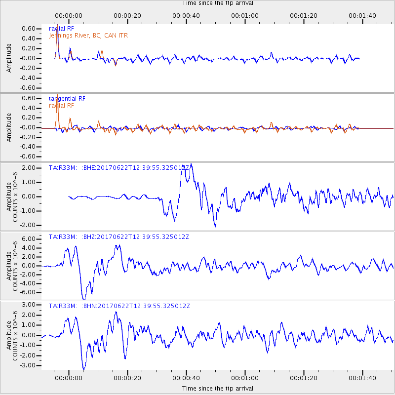
R33M Jennings River, BC, CAN - Earthquake Result Viewer
*The percent match for this event was below the threshold and hence no stack was calculated.
| Earthquake location: |
Near Coast Of Guatemala |
| Earthquake latitude/longitude: |
13.7/-91.1 |
| Earthquake time(UTC): |
2017/06/22 (173) 12:31:04 GMT |
| Earthquake Depth: |
10 km |
| Earthquake Magnitude: |
6.8 Mi |
| Earthquake Catalog/Contributor: |
NEIC PDE/at |
|
| Network: |
TA USArray Transportable Network (new EarthScope stations) |
| Station: |
R33M Jennings River, BC, CAN |
| Lat/Lon: |
59.39 N/130.97 W |
| Elevation: |
1437 m |
|
| Distance: |
54.3 deg |
| Az: |
336.172 deg |
| Baz: |
129.879 deg |
| Ray Param: |
$rayparam |
*The percent match for this event was below the threshold and hence was not used in the summary stack. |
|
| Radial Match: |
95.90597 % |
| Radial Bump: |
396 |
| Transverse Match: |
87.34318 % |
| Transverse Bump: |
400 |
| SOD ConfigId: |
13570011 |
| Insert Time: |
2019-04-28 06:18:21.009 +0000 |
| GWidth: |
2.5 |
| Max Bumps: |
400 |
| Tol: |
0.001 |
|
Signal To Noise
| Channel | StoN | STA | LTA |
| TA:R33M: :BHZ:20170622T12:39:55.325012Z | 47.859978 | 3.4949321E-6 | 7.3024104E-8 |
| TA:R33M: :BHN:20170622T12:39:55.325012Z | 17.827013 | 1.4185671E-6 | 7.9574015E-8 |
| TA:R33M: :BHE:20170622T12:39:55.325012Z | 12.79293 | 1.0829137E-6 | 8.464939E-8 |
| Arrivals |
| Ps | |
| PpPs | |
| PsPs/PpSs | |


