You are here: Home > Network List > TA - USArray Transportable Network (new EarthScope stations) Stations List
> Station 319A Douglas, AZ, USA > Earthquake Result Viewer
319A Douglas, AZ, USA - Earthquake Result Viewer

| Earthquake location: |
Near Coast Of Peru |
| Earthquake latitude/longitude: |
-14.3/-76.1 |
| Earthquake time(UTC): |
2007/08/16 (228) 05:16:56 GMT |
| Earthquake Depth: |
23 km |
| Earthquake Magnitude: |
5.8 MB, 6.1 MS, 6.3 MW, 6.2 ML |
| Earthquake Catalog/Contributor: |
WHDF/NEIC |
|
| Network: |
TA USArray Transportable Network (new EarthScope stations) |
| Station: |
319A Douglas, AZ, USA |
| Lat/Lon: |
31.38 N/109.28 W |
| Elevation: |
1187 m |
|
| Distance: |
55.4 deg |
| Az: |
325.391 deg |
| Baz: |
139.925 deg |
| Ray Param: |
0.06475651 |
| Estimated Moho Depth: |
31.0 km |
| Estimated Crust Vp/Vs: |
1.77 |
| Assumed Crust Vp: |
6.182 km/s |
| Estimated Crust Vs: |
3.488 km/s |
| Estimated Crust Poisson's Ratio: |
0.27 |
|
| Radial Match: |
84.35 % |
| Radial Bump: |
400 |
| Transverse Match: |
77.50994 % |
| Transverse Bump: |
400 |
| SOD ConfigId: |
2564 |
| Insert Time: |
2010-03-06 01:15:40.849 +0000 |
| GWidth: |
2.5 |
| Max Bumps: |
400 |
| Tol: |
0.001 |
|
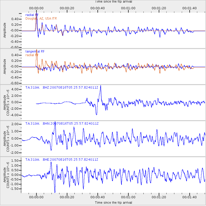
Signal To Noise
| Channel | StoN | STA | LTA |
| TA:319A: :BHN:20070816T05:25:57.824011Z | 1.434837 | 2.1839426E-7 | 1.5220841E-7 |
| TA:319A: :BHE:20070816T05:25:57.824011Z | 1.0724984 | 1.6027396E-7 | 1.4943981E-7 |
| TA:319A: :BHZ:20070816T05:25:57.824011Z | 2.3459241 | 4.6255803E-7 | 1.9717518E-7 |
| Arrivals |
| Ps | 4.1 SECOND |
| PpPs | 13 SECOND |
| PsPs/PpSs | 17 SECOND |


