You are here: Home > Network List > TA - USArray Transportable Network (new EarthScope stations) Stations List
> Station 319A Douglas, AZ, USA > Earthquake Result Viewer
319A Douglas, AZ, USA - Earthquake Result Viewer

| Earthquake location: |
Komandorskiye Ostrova Region |
| Earthquake latitude/longitude: |
53.6/169.7 |
| Earthquake time(UTC): |
2007/07/29 (210) 04:54:36 GMT |
| Earthquake Depth: |
26 km |
| Earthquake Magnitude: |
6.0 MB, 5.5 MS, 5.9 MW, 5.8 MW |
| Earthquake Catalog/Contributor: |
WHDF/NEIC |
|
| Network: |
TA USArray Transportable Network (new EarthScope stations) |
| Station: |
319A Douglas, AZ, USA |
| Lat/Lon: |
31.38 N/109.28 W |
| Elevation: |
1187 m |
|
| Distance: |
60.3 deg |
| Az: |
76.605 deg |
| Baz: |
317.374 deg |
| Ray Param: |
0.061599325 |
| Estimated Moho Depth: |
31.5 km |
| Estimated Crust Vp/Vs: |
1.72 |
| Assumed Crust Vp: |
6.182 km/s |
| Estimated Crust Vs: |
3.6 km/s |
| Estimated Crust Poisson's Ratio: |
0.24 |
|
| Radial Match: |
87.69071 % |
| Radial Bump: |
400 |
| Transverse Match: |
90.82769 % |
| Transverse Bump: |
400 |
| SOD ConfigId: |
2564 |
| Insert Time: |
2010-03-06 01:15:48.997 +0000 |
| GWidth: |
2.5 |
| Max Bumps: |
400 |
| Tol: |
0.001 |
|
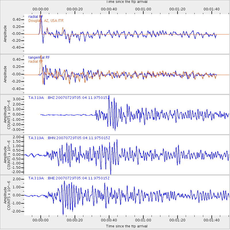
Signal To Noise
| Channel | StoN | STA | LTA |
| TA:319A: :BHN:20070729T05:04:11.975015Z | 1.9518607 | 1.130551E-7 | 5.7921707E-8 |
| TA:319A: :BHE:20070729T05:04:11.975015Z | 2.160413 | 1.4388851E-7 | 6.660231E-8 |
| TA:319A: :BHZ:20070729T05:04:11.975015Z | 10.2941265 | 4.251643E-7 | 4.1301643E-8 |
| Arrivals |
| Ps | 3.8 SECOND |
| PpPs | 13 SECOND |
| PsPs/PpSs | 17 SECOND |


