You are here: Home > Network List > TA - USArray Transportable Network (new EarthScope stations) Stations List
> Station MSTX Muleshoe, TX, USA > Earthquake Result Viewer
MSTX Muleshoe, TX, USA - Earthquake Result Viewer
*The percent match for this event was below the threshold and hence no stack was calculated.
| Earthquake location: |
Southern Peru |
| Earthquake latitude/longitude: |
-15.5/-73.5 |
| Earthquake time(UTC): |
2017/06/24 (175) 16:09:11 GMT |
| Earthquake Depth: |
69 km |
| Earthquake Magnitude: |
5.7 Mww |
| Earthquake Catalog/Contributor: |
NEIC PDE/us |
|
| Network: |
TA USArray Transportable Network (new EarthScope stations) |
| Station: |
MSTX Muleshoe, TX, USA |
| Lat/Lon: |
33.97 N/102.77 W |
| Elevation: |
1167 m |
|
| Distance: |
56.5 deg |
| Az: |
330.806 deg |
| Baz: |
145.534 deg |
| Ray Param: |
$rayparam |
*The percent match for this event was below the threshold and hence was not used in the summary stack. |
|
| Radial Match: |
63.95616 % |
| Radial Bump: |
400 |
| Transverse Match: |
68.25198 % |
| Transverse Bump: |
400 |
| SOD ConfigId: |
13570011 |
| Insert Time: |
2019-04-28 06:32:01.305 +0000 |
| GWidth: |
2.5 |
| Max Bumps: |
400 |
| Tol: |
0.001 |
|
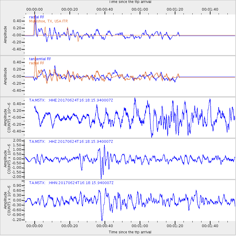
Signal To Noise
| Channel | StoN | STA | LTA |
| TA:MSTX: :HHZ:20170624T16:18:15.940007Z | 2.5740654 | 3.0216754E-7 | 1.1738922E-7 |
| TA:MSTX: :HHN:20170624T16:18:15.940007Z | 1.313133 | 1.7568256E-7 | 1.3378886E-7 |
| TA:MSTX: :HHE:20170624T16:18:15.940007Z | 1.1864529 | 1.3788208E-7 | 1.16213705E-7 |
| Arrivals |
| Ps | |
| PpPs | |
| PsPs/PpSs | |


