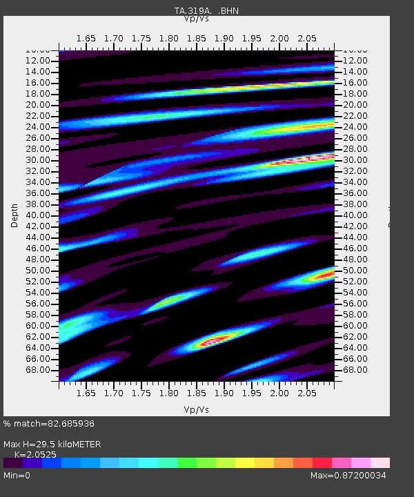
319A Douglas, AZ, USA - Earthquake Result Viewer
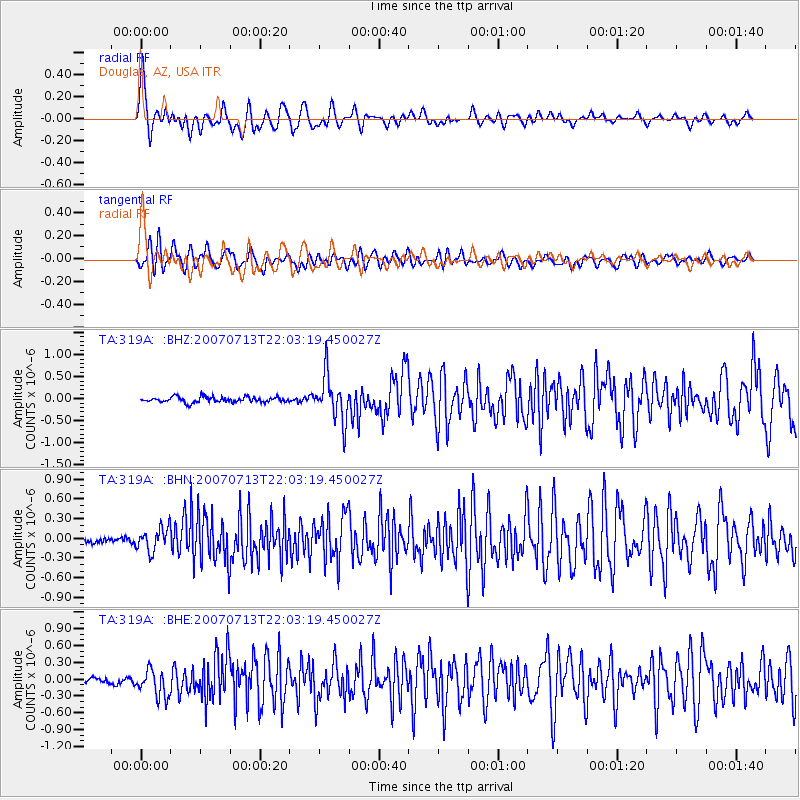
Earthquake location: Andreanof Islands, Aleutian Is.
Earthquake latitude/longitude: 51.8/-176.3
Earthquake time(UTC): 2007/07/13 (194) 21:54:43 GMT
Earthquake Depth: 35 km
Earthquake Magnitude: 5.7 MB, 5.6 MS, 6.0 MW, 5.9 MW
Earthquake Catalog/Contributor: WHDF/NEIC
Network: TA USArray Transportable Network (new EarthScope stations)
Station: 319A Douglas, AZ, USA
Lat/Lon: 31.38 N/109.28 W
Elevation: 1187 m
Distance: 52.1 deg
Az: 85.689 deg
Baz: 313.668 deg
Ray Param: 0.06688118
Estimated Moho Depth: 29.5 km
Estimated Crust Vp/Vs: 2.05
Assumed Crust Vp: 6.182 km/s
Estimated Crust Vs: 3.012 km/s
Estimated Crust Poisson's Ratio: 0.34
Radial Match: 82.685936 %
Radial Bump: 400
Transverse Match: 75.42565 %
Transverse Bump: 400
SOD ConfigId: 2564
Insert Time: 2010-03-06 01:15:59.071 +0000
GWidth: 2.5
Max Bumps: 400
Tol: 0.001

Signal To Noise

ChannelStoNSTALTA
TA:319A: :BHN:20070713T22:03:19.450027Z3.4067791.7313268E-75.0820052E-8
TA:319A: :BHE:20070713T22:03:19.450027Z4.6303662.4672292E-75.3283678E-8
TA:319A: :BHZ:20070713T22:03:19.450027Z8.191975.0968043E-76.2217076E-8
Arrivals
Ps5.2 SECOND
PpPs14 SECOND
PsPs/PpSs19 SECOND