You are here: Home > Network List > TA - USArray Transportable Network (new EarthScope stations) Stations List
> Station R31K City Hall, Gustavus, AK, USA > Earthquake Result Viewer
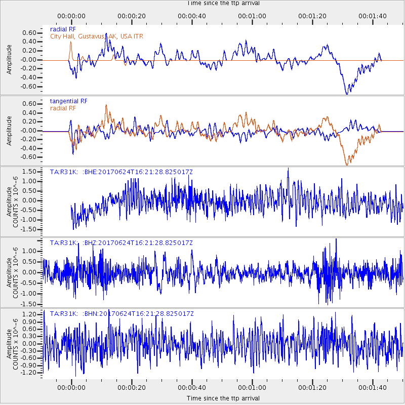
R31K City Hall, Gustavus, AK, USA - Earthquake Result Viewer
*The percent match for this event was below the threshold and hence no stack was calculated.
| Earthquake location: |
Southern Peru |
| Earthquake latitude/longitude: |
-15.5/-73.5 |
| Earthquake time(UTC): |
2017/06/24 (175) 16:09:11 GMT |
| Earthquake Depth: |
69 km |
| Earthquake Magnitude: |
5.7 Mww |
| Earthquake Catalog/Contributor: |
NEIC PDE/us |
|
| Network: |
TA USArray Transportable Network (new EarthScope stations) |
| Station: |
R31K City Hall, Gustavus, AK, USA |
| Lat/Lon: |
58.41 N/135.74 W |
| Elevation: |
15 m |
|
| Distance: |
89.4 deg |
| Az: |
332.225 deg |
| Baz: |
121.387 deg |
| Ray Param: |
$rayparam |
*The percent match for this event was below the threshold and hence was not used in the summary stack. |
|
| Radial Match: |
22.24083 % |
| Radial Bump: |
400 |
| Transverse Match: |
43.757626 % |
| Transverse Bump: |
400 |
| SOD ConfigId: |
13570011 |
| Insert Time: |
2019-04-28 06:32:13.895 +0000 |
| GWidth: |
2.5 |
| Max Bumps: |
400 |
| Tol: |
0.001 |
|
Signal To Noise
| Channel | StoN | STA | LTA |
| TA:R31K: :BHZ:20170624T16:21:28.825017Z | 1.7320681 | 4.4412135E-7 | 2.5641103E-7 |
| TA:R31K: :BHN:20170624T16:21:28.825017Z | 1.2251093 | 5.4591914E-7 | 4.4560846E-7 |
| TA:R31K: :BHE:20170624T16:21:28.825017Z | 0.90729487 | 4.923543E-7 | 5.426618E-7 |
| Arrivals |
| Ps | |
| PpPs | |
| PsPs/PpSs | |


