You are here: Home > Network List > GS - US Geological Survey Networks Stations List
> Station KAN08 Pence Farm, Harper, KS, USA > Earthquake Result Viewer
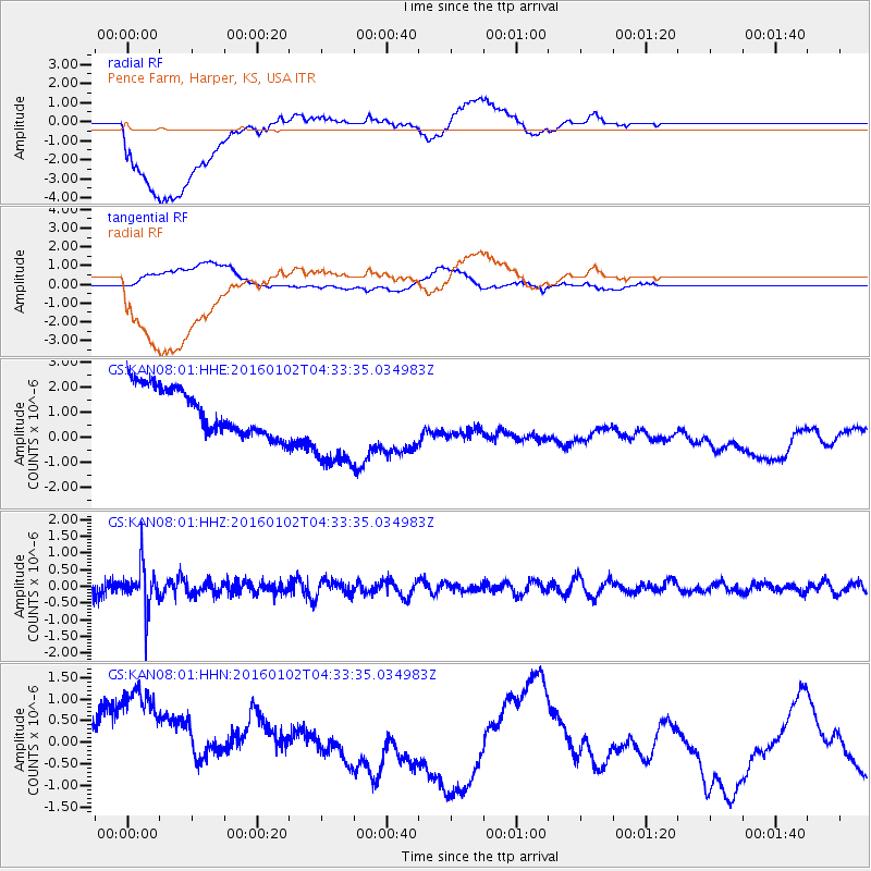
KAN08 Pence Farm, Harper, KS, USA - Earthquake Result Viewer
*The percent match for this event was below the threshold and hence no stack was calculated.
| Earthquake location: |
Northeastern China |
| Earthquake latitude/longitude: |
44.9/130.0 |
| Earthquake time(UTC): |
2016/01/02 (002) 04:22:19 GMT |
| Earthquake Depth: |
583 km |
| Earthquake Magnitude: |
5.7 MWP |
| Earthquake Catalog/Contributor: |
NEIC PDE/NEIC COMCAT |
|
| Network: |
GS US Geological Survey Networks |
| Station: |
KAN08 Pence Farm, Harper, KS, USA |
| Lat/Lon: |
37.23 N/97.97 W |
| Elevation: |
375 m |
|
| Distance: |
87.5 deg |
| Az: |
36.382 deg |
| Baz: |
328.098 deg |
| Ray Param: |
$rayparam |
*The percent match for this event was below the threshold and hence was not used in the summary stack. |
|
| Radial Match: |
23.62119 % |
| Radial Bump: |
400 |
| Transverse Match: |
24.950489 % |
| Transverse Bump: |
400 |
| SOD ConfigId: |
1379111 |
| Insert Time: |
2016-01-16 05:01:41.757 +0000 |
| GWidth: |
2.5 |
| Max Bumps: |
400 |
| Tol: |
0.001 |
|
Signal To Noise
| Channel | StoN | STA | LTA |
| GS:KAN08:01:HHZ:20160102T04:33:35.034983Z | 3.0231824 | 6.523451E-7 | 2.1578093E-7 |
| GS:KAN08:01:HHN:20160102T04:33:35.034983Z | 1.5709176 | 2.2358886E-6 | 1.423301E-6 |
| GS:KAN08:01:HHE:20160102T04:33:35.034983Z | 2.0462875 | 1.9145664E-6 | 9.3562915E-7 |
| Arrivals |
| Ps | |
| PpPs | |
| PsPs/PpSs | |


