You are here: Home > Network List > GS - US Geological Survey Networks Stations List
> Station KAN10 Keim Farm, Anthony, KS, USA > Earthquake Result Viewer
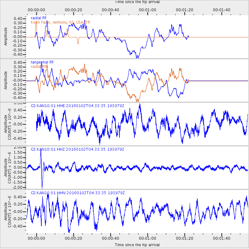
KAN10 Keim Farm, Anthony, KS, USA - Earthquake Result Viewer
*The percent match for this event was below the threshold and hence no stack was calculated.
| Earthquake location: |
Northeastern China |
| Earthquake latitude/longitude: |
44.9/130.0 |
| Earthquake time(UTC): |
2016/01/02 (002) 04:22:19 GMT |
| Earthquake Depth: |
583 km |
| Earthquake Magnitude: |
5.7 MWP |
| Earthquake Catalog/Contributor: |
NEIC PDE/NEIC COMCAT |
|
| Network: |
GS US Geological Survey Networks |
| Station: |
KAN10 Keim Farm, Anthony, KS, USA |
| Lat/Lon: |
37.12 N/98.10 W |
| Elevation: |
417 m |
|
| Distance: |
87.6 deg |
| Az: |
36.521 deg |
| Baz: |
328.029 deg |
| Ray Param: |
$rayparam |
*The percent match for this event was below the threshold and hence was not used in the summary stack. |
|
| Radial Match: |
54.863293 % |
| Radial Bump: |
400 |
| Transverse Match: |
55.45666 % |
| Transverse Bump: |
400 |
| SOD ConfigId: |
1379111 |
| Insert Time: |
2016-01-16 05:01:46.279 +0000 |
| GWidth: |
2.5 |
| Max Bumps: |
400 |
| Tol: |
0.001 |
|
Signal To Noise
| Channel | StoN | STA | LTA |
| GS:KAN10:01:HHZ:20160102T04:33:35.193979Z | 4.755063 | 7.2431425E-7 | 1.5232484E-7 |
| GS:KAN10:01:HHN:20160102T04:33:35.193979Z | 0.70557547 | 1.4491243E-7 | 2.0538191E-7 |
| GS:KAN10:01:HHE:20160102T04:33:35.193979Z | 1.270455 | 2.3164398E-7 | 1.8233152E-7 |
| Arrivals |
| Ps | |
| PpPs | |
| PsPs/PpSs | |


