You are here: Home > Network List > GS - US Geological Survey Networks Stations List
> Station KAN11 Stewart Ranch, Harper County, KS, USA > Earthquake Result Viewer
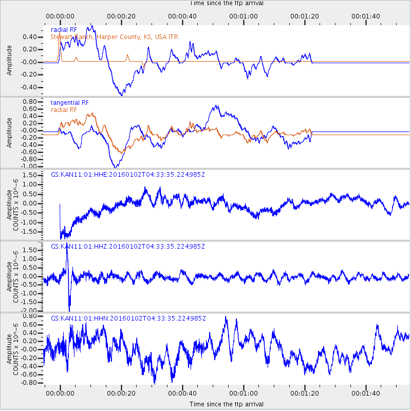
KAN11 Stewart Ranch, Harper County, KS, USA - Earthquake Result Viewer
*The percent match for this event was below the threshold and hence no stack was calculated.
| Earthquake location: |
Northeastern China |
| Earthquake latitude/longitude: |
44.9/130.0 |
| Earthquake time(UTC): |
2016/01/02 (002) 04:22:19 GMT |
| Earthquake Depth: |
583 km |
| Earthquake Magnitude: |
5.7 MWP |
| Earthquake Catalog/Contributor: |
NEIC PDE/NEIC COMCAT |
|
| Network: |
GS US Geological Survey Networks |
| Station: |
KAN11 Stewart Ranch, Harper County, KS, USA |
| Lat/Lon: |
37.21 N/97.91 W |
| Elevation: |
410 m |
|
| Distance: |
87.6 deg |
| Az: |
36.354 deg |
| Baz: |
328.132 deg |
| Ray Param: |
$rayparam |
*The percent match for this event was below the threshold and hence was not used in the summary stack. |
|
| Radial Match: |
33.677032 % |
| Radial Bump: |
400 |
| Transverse Match: |
17.15502 % |
| Transverse Bump: |
400 |
| SOD ConfigId: |
1379111 |
| Insert Time: |
2016-01-16 05:01:50.863 +0000 |
| GWidth: |
2.5 |
| Max Bumps: |
400 |
| Tol: |
0.001 |
|
Signal To Noise
| Channel | StoN | STA | LTA |
| GS:KAN11:01:HHZ:20160102T04:33:35.224985Z | 4.8760147 | 7.358352E-7 | 1.5090914E-7 |
| GS:KAN11:01:HHN:20160102T04:33:35.224985Z | 0.89573777 | 4.967514E-7 | 5.5457235E-7 |
| GS:KAN11:01:HHE:20160102T04:33:35.224985Z | 1.4967198 | 8.56836E-7 | 5.7247587E-7 |
| Arrivals |
| Ps | |
| PpPs | |
| PsPs/PpSs | |


