You are here: Home > Network List > TA - USArray Transportable Network (new EarthScope stations) Stations List
> Station 319A Douglas, AZ, USA > Earthquake Result Viewer
319A Douglas, AZ, USA - Earthquake Result Viewer

| Earthquake location: |
Tonga Islands Region |
| Earthquake latitude/longitude: |
-23.0/-174.7 |
| Earthquake time(UTC): |
2009/03/19 (078) 18:17:40 GMT |
| Earthquake Depth: |
34 km |
| Earthquake Magnitude: |
7.0 MB, 7.6 MS, 7.6 MW, 7.6 MW |
| Earthquake Catalog/Contributor: |
WHDF/NEIC |
|
| Network: |
TA USArray Transportable Network (new EarthScope stations) |
| Station: |
319A Douglas, AZ, USA |
| Lat/Lon: |
31.38 N/109.28 W |
| Elevation: |
1187 m |
|
| Distance: |
82.7 deg |
| Az: |
51.615 deg |
| Baz: |
237.583 deg |
| Ray Param: |
0.04664001 |
| Estimated Moho Depth: |
29.25 km |
| Estimated Crust Vp/Vs: |
1.80 |
| Assumed Crust Vp: |
6.182 km/s |
| Estimated Crust Vs: |
3.439 km/s |
| Estimated Crust Poisson's Ratio: |
0.28 |
|
| Radial Match: |
96.82887 % |
| Radial Bump: |
400 |
| Transverse Match: |
83.64861 % |
| Transverse Bump: |
400 |
| SOD ConfigId: |
2658 |
| Insert Time: |
2010-03-06 01:16:19.829 +0000 |
| GWidth: |
2.5 |
| Max Bumps: |
400 |
| Tol: |
0.001 |
|
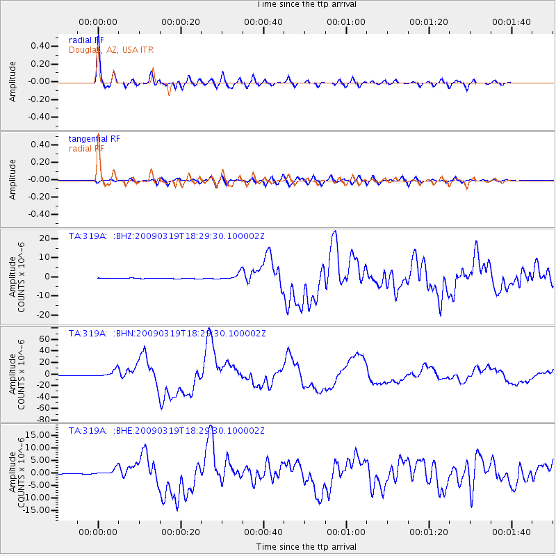
Signal To Noise
| Channel | StoN | STA | LTA |
| TA:319A: :BHN:20090319T18:29:30.100002Z | 22.660925 | 6.653335E-6 | 2.9360385E-7 |
| TA:319A: :BHE:20090319T18:29:30.100002Z | 10.20606 | 1.350588E-6 | 1.3233198E-7 |
| TA:319A: :BHZ:20090319T18:29:30.100002Z | 14.520692 | 2.018277E-6 | 1.3899317E-7 |
| Arrivals |
| Ps | 3.9 SECOND |
| PpPs | 13 SECOND |
| PsPs/PpSs | 17 SECOND |


