You are here: Home > Network List > TA - USArray Transportable Network (new EarthScope stations) Stations List
> Station 319A Douglas, AZ, USA > Earthquake Result Viewer
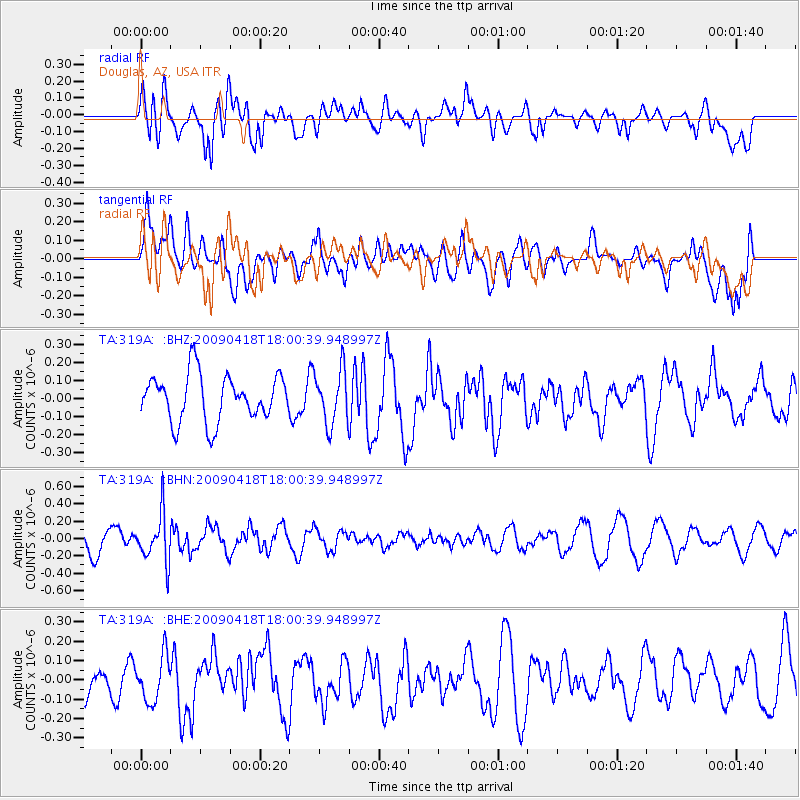
319A Douglas, AZ, USA - Earthquake Result Viewer
*The percent match for this event was below the threshold and hence no stack was calculated.
| Earthquake location: |
Fiji Islands Region |
| Earthquake latitude/longitude: |
-20.6/-178.5 |
| Earthquake time(UTC): |
2009/04/18 (108) 17:49:39 GMT |
| Earthquake Depth: |
566 km |
| Earthquake Magnitude: |
5.7 MW, 5.0 MB, 5.7 MW |
| Earthquake Catalog/Contributor: |
WHDF/NEIC |
|
| Network: |
TA USArray Transportable Network (new EarthScope stations) |
| Station: |
319A Douglas, AZ, USA |
| Lat/Lon: |
31.38 N/109.28 W |
| Elevation: |
1187 m |
|
| Distance: |
84.1 deg |
| Az: |
53.501 deg |
| Baz: |
241.692 deg |
| Ray Param: |
$rayparam |
*The percent match for this event was below the threshold and hence was not used in the summary stack. |
|
| Radial Match: |
63.280933 % |
| Radial Bump: |
400 |
| Transverse Match: |
44.453663 % |
| Transverse Bump: |
400 |
| SOD ConfigId: |
2760 |
| Insert Time: |
2010-03-06 01:16:45.605 +0000 |
| GWidth: |
2.5 |
| Max Bumps: |
400 |
| Tol: |
0.001 |
|
Signal To Noise
| Channel | StoN | STA | LTA |
| TA:319A: :BHN:20090418T18:00:39.948997Z | 2.171586 | 2.749356E-7 | 1.266059E-7 |
| TA:319A: :BHE:20090418T18:00:39.948997Z | 0.8945071 | 1.1733878E-7 | 1.3117703E-7 |
| TA:319A: :BHZ:20090418T18:00:39.948997Z | 1.1673434 | 1.496945E-7 | 1.2823519E-7 |
| Arrivals |
| Ps | |
| PpPs | |
| PsPs/PpSs | |


