You are here: Home > Network List > TA - USArray Transportable Network (new EarthScope stations) Stations List
> Station 319A Douglas, AZ, USA > Earthquake Result Viewer
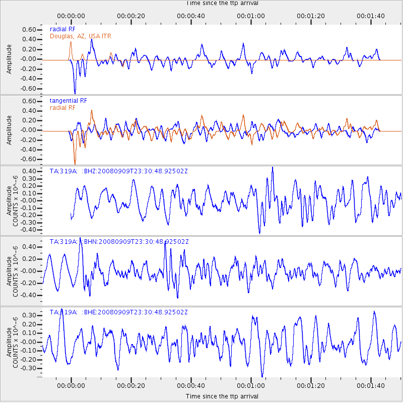
319A Douglas, AZ, USA - Earthquake Result Viewer
*The percent match for this event was below the threshold and hence no stack was calculated.
| Earthquake location: |
Santa Cruz Islands |
| Earthquake latitude/longitude: |
-11.8/166.5 |
| Earthquake time(UTC): |
2008/09/09 (253) 23:18:26 GMT |
| Earthquake Depth: |
99 km |
| Earthquake Magnitude: |
5.6 MW, 5.4 MB, 5.6 MW |
| Earthquake Catalog/Contributor: |
WHDF/NEIC |
|
| Network: |
TA USArray Transportable Network (new EarthScope stations) |
| Station: |
319A Douglas, AZ, USA |
| Lat/Lon: |
31.38 N/109.28 W |
| Elevation: |
1187 m |
|
| Distance: |
91.2 deg |
| Az: |
58.336 deg |
| Baz: |
256.996 deg |
| Ray Param: |
$rayparam |
*The percent match for this event was below the threshold and hence was not used in the summary stack. |
|
| Radial Match: |
57.19182 % |
| Radial Bump: |
400 |
| Transverse Match: |
64.52099 % |
| Transverse Bump: |
400 |
| SOD ConfigId: |
2504 |
| Insert Time: |
2010-03-06 01:16:46.990 +0000 |
| GWidth: |
2.5 |
| Max Bumps: |
400 |
| Tol: |
0.001 |
|
Signal To Noise
| Channel | StoN | STA | LTA |
| TA:319A: :BHN:20080909T23:30:48.92502Z | 2.247495 | 2.5437242E-7 | 1.1318042E-7 |
| TA:319A: :BHE:20080909T23:30:48.92502Z | 0.8946915 | 1.328513E-7 | 1.4848837E-7 |
| TA:319A: :BHZ:20080909T23:30:48.92502Z | 1.1334215 | 1.5889141E-7 | 1.401874E-7 |
| Arrivals |
| Ps | |
| PpPs | |
| PsPs/PpSs | |


