You are here: Home > Network List > TA - USArray Transportable Network (new EarthScope stations) Stations List
> Station 319A Douglas, AZ, USA > Earthquake Result Viewer
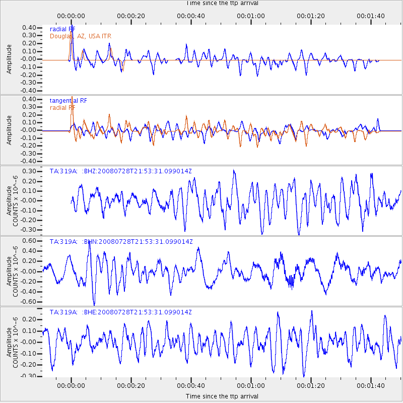
319A Douglas, AZ, USA - Earthquake Result Viewer
*The percent match for this event was below the threshold and hence no stack was calculated.
| Earthquake location: |
Solomon Islands |
| Earthquake latitude/longitude: |
-10.6/163.1 |
| Earthquake time(UTC): |
2008/07/28 (210) 21:40:47 GMT |
| Earthquake Depth: |
10 km |
| Earthquake Magnitude: |
5.9 MB, 5.8 MS, 6.0 MW |
| Earthquake Catalog/Contributor: |
WHDF/NEIC |
|
| Network: |
TA USArray Transportable Network (new EarthScope stations) |
| Station: |
319A Douglas, AZ, USA |
| Lat/Lon: |
31.38 N/109.28 W |
| Elevation: |
1187 m |
|
| Distance: |
93.4 deg |
| Az: |
58.881 deg |
| Baz: |
259.776 deg |
| Ray Param: |
$rayparam |
*The percent match for this event was below the threshold and hence was not used in the summary stack. |
|
| Radial Match: |
76.58941 % |
| Radial Bump: |
400 |
| Transverse Match: |
59.994987 % |
| Transverse Bump: |
400 |
| SOD ConfigId: |
2504 |
| Insert Time: |
2010-03-06 01:17:18.280 +0000 |
| GWidth: |
2.5 |
| Max Bumps: |
400 |
| Tol: |
0.001 |
|
Signal To Noise
| Channel | StoN | STA | LTA |
| TA:319A: :BHN:20080728T21:53:31.099014Z | 2.54321 | 2.0324288E-7 | 7.991588E-8 |
| TA:319A: :BHE:20080728T21:53:31.099014Z | 0.8094324 | 7.177466E-8 | 8.867282E-8 |
| TA:319A: :BHZ:20080728T21:53:31.099014Z | 1.0636506 | 7.66484E-8 | 7.206163E-8 |
| Arrivals |
| Ps | |
| PpPs | |
| PsPs/PpSs | |


