You are here: Home > Network List > TA - USArray Transportable Network (new EarthScope stations) Stations List
> Station 319A Douglas, AZ, USA > Earthquake Result Viewer
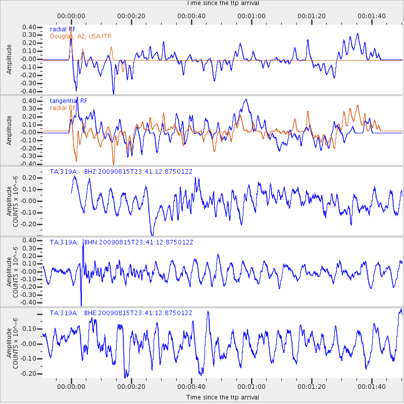
319A Douglas, AZ, USA - Earthquake Result Viewer
*The percent match for this event was below the threshold and hence no stack was calculated.
| Earthquake location: |
Fiji Islands Region |
| Earthquake latitude/longitude: |
-19.8/-178.2 |
| Earthquake time(UTC): |
2009/08/15 (227) 23:30:19 GMT |
| Earthquake Depth: |
608 km |
| Earthquake Magnitude: |
5.6 MW, 5.2 MB |
| Earthquake Catalog/Contributor: |
WHDF/NEIC |
|
| Network: |
TA USArray Transportable Network (new EarthScope stations) |
| Station: |
319A Douglas, AZ, USA |
| Lat/Lon: |
31.38 N/109.28 W |
| Elevation: |
1187 m |
|
| Distance: |
83.4 deg |
| Az: |
53.472 deg |
| Baz: |
242.188 deg |
| Ray Param: |
$rayparam |
*The percent match for this event was below the threshold and hence was not used in the summary stack. |
|
| Radial Match: |
57.157604 % |
| Radial Bump: |
400 |
| Transverse Match: |
47.09426 % |
| Transverse Bump: |
400 |
| SOD ConfigId: |
2622 |
| Insert Time: |
2010-03-06 01:17:29.772 +0000 |
| GWidth: |
2.5 |
| Max Bumps: |
400 |
| Tol: |
0.001 |
|
Signal To Noise
| Channel | StoN | STA | LTA |
| TA:319A: :BHN:20090815T23:41:12.875012Z | 2.4395802 | 1.4115528E-7 | 5.786048E-8 |
| TA:319A: :BHE:20090815T23:41:12.875012Z | 1.2234944 | 1.1321048E-7 | 9.253044E-8 |
| TA:319A: :BHZ:20090815T23:41:12.875012Z | 1.2448863 | 1.0488538E-7 | 8.425298E-8 |
| Arrivals |
| Ps | |
| PpPs | |
| PsPs/PpSs | |


