You are here: Home > Network List > TA - USArray Transportable Network (new EarthScope stations) Stations List
> Station 319A Douglas, AZ, USA > Earthquake Result Viewer
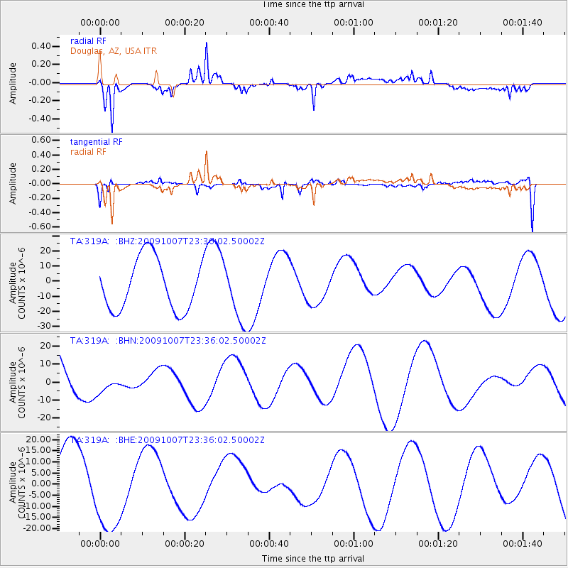
319A Douglas, AZ, USA - Earthquake Result Viewer
*The percent match for this event was below the threshold and hence no stack was calculated.
| Earthquake location: |
Santa Cruz Islands |
| Earthquake latitude/longitude: |
-12.6/166.0 |
| Earthquake time(UTC): |
2009/10/07 (280) 23:23:28 GMT |
| Earthquake Depth: |
36 km |
| Earthquake Magnitude: |
5.5 MB |
| Earthquake Catalog/Contributor: |
WHDF/NEIC |
|
| Network: |
TA USArray Transportable Network (new EarthScope stations) |
| Station: |
319A Douglas, AZ, USA |
| Lat/Lon: |
31.38 N/109.28 W |
| Elevation: |
1187 m |
|
| Distance: |
92.0 deg |
| Az: |
58.462 deg |
| Baz: |
256.632 deg |
| Ray Param: |
$rayparam |
*The percent match for this event was below the threshold and hence was not used in the summary stack. |
|
| Radial Match: |
94.44393 % |
| Radial Bump: |
400 |
| Transverse Match: |
55.798695 % |
| Transverse Bump: |
351 |
| SOD ConfigId: |
2622 |
| Insert Time: |
2010-03-06 01:17:41.287 +0000 |
| GWidth: |
2.5 |
| Max Bumps: |
400 |
| Tol: |
0.001 |
|
Signal To Noise
| Channel | StoN | STA | LTA |
| TA:319A: :BHN:20091007T23:36:02.50002Z | 0.32007328 | 6.9213097E-6 | 2.162414E-5 |
| TA:319A: :BHE:20091007T23:36:02.50002Z | 1.6053168 | 2.0683457E-5 | 1.2884346E-5 |
| TA:319A: :BHZ:20091007T23:36:02.50002Z | 1.1462075 | 1.945044E-5 | 1.6969387E-5 |
| Arrivals |
| Ps | |
| PpPs | |
| PsPs/PpSs | |


