You are here: Home > Network List > TA - USArray Transportable Network (new EarthScope stations) Stations List
> Station 319A Douglas, AZ, USA > Earthquake Result Viewer
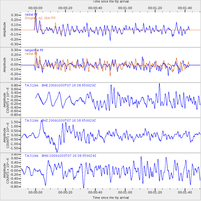
319A Douglas, AZ, USA - Earthquake Result Viewer
*The percent match for this event was below the threshold and hence no stack was calculated.
| Earthquake location: |
Ryukyu Islands, Japan |
| Earthquake latitude/longitude: |
29.2/129.8 |
| Earthquake time(UTC): |
2009/10/30 (303) 07:03:39 GMT |
| Earthquake Depth: |
34 km |
| Earthquake Magnitude: |
6.3 MB, 6.8 MS, 6.8 MW, 6.8 MW |
| Earthquake Catalog/Contributor: |
WHDF/NEIC |
|
| Network: |
TA USArray Transportable Network (new EarthScope stations) |
| Station: |
319A Douglas, AZ, USA |
| Lat/Lon: |
31.38 N/109.28 W |
| Elevation: |
1187 m |
|
| Distance: |
97.6 deg |
| Az: |
47.748 deg |
| Baz: |
310.844 deg |
| Ray Param: |
$rayparam |
*The percent match for this event was below the threshold and hence was not used in the summary stack. |
|
| Radial Match: |
71.793335 % |
| Radial Bump: |
400 |
| Transverse Match: |
55.407288 % |
| Transverse Bump: |
400 |
| SOD ConfigId: |
2622 |
| Insert Time: |
2010-03-06 01:17:46.058 +0000 |
| GWidth: |
2.5 |
| Max Bumps: |
400 |
| Tol: |
0.001 |
|
Signal To Noise
| Channel | StoN | STA | LTA |
| TA:319A: :BHZ:20091030T07:16:38.650029Z | 3.9864547 | 8.3823255E-7 | 2.1027017E-7 |
| TA:319A: :BHN:20091030T07:16:38.650029Z | 0.56761956 | 1.0590962E-7 | 1.8658558E-7 |
| TA:319A: :BHE:20091030T07:16:38.650029Z | 0.6617393 | 1.481288E-7 | 2.2384766E-7 |
| Arrivals |
| Ps | |
| PpPs | |
| PsPs/PpSs | |


