You are here: Home > Network List > IU - Global Seismograph Network (GSN - IRIS/USGS) Stations List
> Station RSSD Black Hills, South Dakota, USA > Earthquake Result Viewer
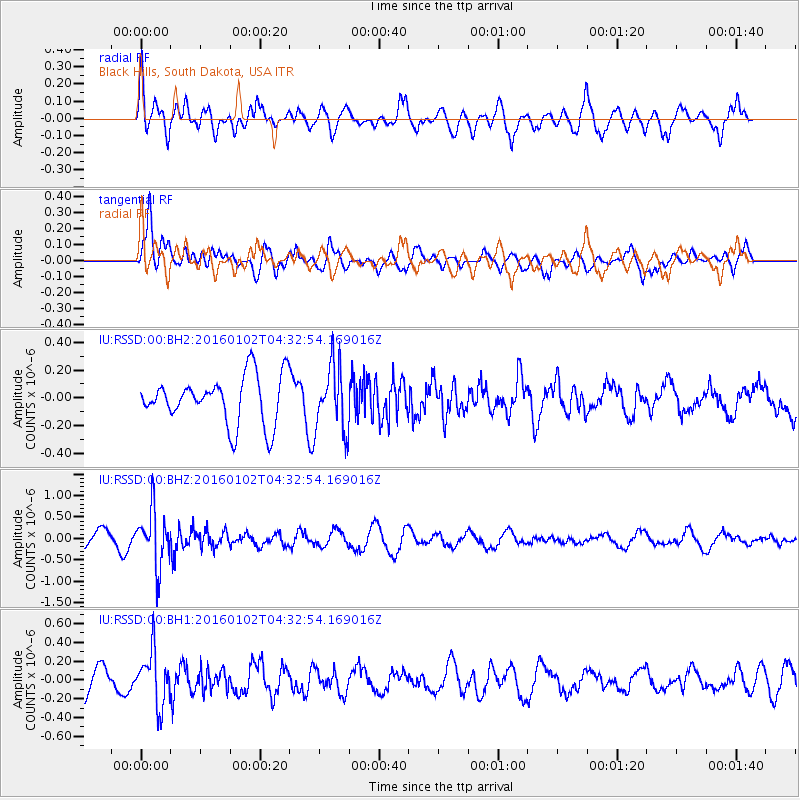
RSSD Black Hills, South Dakota, USA - Earthquake Result Viewer
*The percent match for this event was below the threshold and hence no stack was calculated.
| Earthquake location: |
Northeastern China |
| Earthquake latitude/longitude: |
44.9/130.0 |
| Earthquake time(UTC): |
2016/01/02 (002) 04:22:19 GMT |
| Earthquake Depth: |
583 km |
| Earthquake Magnitude: |
5.7 MWP |
| Earthquake Catalog/Contributor: |
NEIC PDE/NEIC COMCAT |
|
| Network: |
IU Global Seismograph Network (GSN - IRIS/USGS) |
| Station: |
RSSD Black Hills, South Dakota, USA |
| Lat/Lon: |
44.12 N/104.04 W |
| Elevation: |
2090 m |
|
| Distance: |
79.2 deg |
| Az: |
36.379 deg |
| Baz: |
324.151 deg |
| Ray Param: |
$rayparam |
*The percent match for this event was below the threshold and hence was not used in the summary stack. |
|
| Radial Match: |
61.256084 % |
| Radial Bump: |
400 |
| Transverse Match: |
50.799507 % |
| Transverse Bump: |
400 |
| SOD ConfigId: |
1379111 |
| Insert Time: |
2016-01-16 05:06:53.981 +0000 |
| GWidth: |
2.5 |
| Max Bumps: |
400 |
| Tol: |
0.001 |
|
Signal To Noise
| Channel | StoN | STA | LTA |
| IU:RSSD:00:BHZ:20160102T04:32:54.169016Z | 4.516047 | 6.382778E-7 | 1.413355E-7 |
| IU:RSSD:00:BH1:20160102T04:32:54.169016Z | 2.0485384 | 2.9021922E-7 | 1.4167135E-7 |
| IU:RSSD:00:BH2:20160102T04:32:54.169016Z | 1.3736558 | 2.370007E-7 | 1.7253282E-7 |
| Arrivals |
| Ps | |
| PpPs | |
| PsPs/PpSs | |


