You are here: Home > Network List > TA - USArray Transportable Network (new EarthScope stations) Stations List
> Station D23K Nanushuk River, AK USA > Earthquake Result Viewer
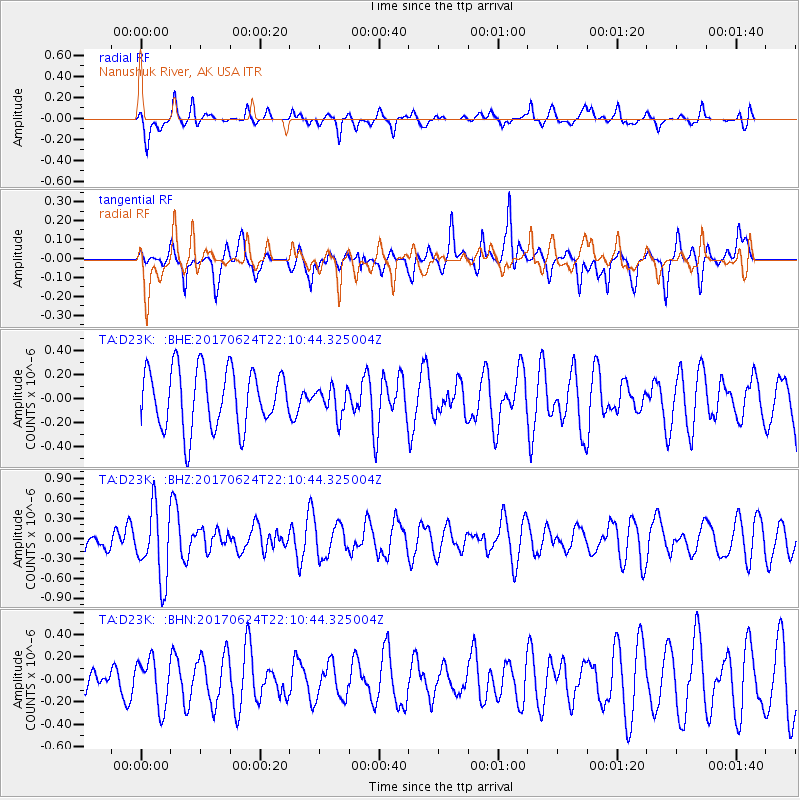
D23K Nanushuk River, AK USA - Earthquake Result Viewer
*The percent match for this event was below the threshold and hence no stack was calculated.
| Earthquake location: |
Eastern Honshu, Japan |
| Earthquake latitude/longitude: |
35.8/137.6 |
| Earthquake time(UTC): |
2017/06/24 (175) 22:02:16 GMT |
| Earthquake Depth: |
10 km |
| Earthquake Magnitude: |
5.2 Mww |
| Earthquake Catalog/Contributor: |
NEIC PDE/us |
|
| Network: |
TA USArray Transportable Network (new EarthScope stations) |
| Station: |
D23K Nanushuk River, AK USA |
| Lat/Lon: |
68.97 N/150.68 W |
| Elevation: |
406 m |
|
| Distance: |
50.5 deg |
| Az: |
26.355 deg |
| Baz: |
267.955 deg |
| Ray Param: |
$rayparam |
*The percent match for this event was below the threshold and hence was not used in the summary stack. |
|
| Radial Match: |
54.60102 % |
| Radial Bump: |
400 |
| Transverse Match: |
67.16984 % |
| Transverse Bump: |
400 |
| SOD ConfigId: |
13570011 |
| Insert Time: |
2019-04-28 06:45:48.007 +0000 |
| GWidth: |
2.5 |
| Max Bumps: |
400 |
| Tol: |
0.001 |
|
Signal To Noise
| Channel | StoN | STA | LTA |
| TA:D23K: :BHZ:20170624T22:10:44.325004Z | 3.0362318 | 5.3414016E-7 | 1.7592207E-7 |
| TA:D23K: :BHN:20170624T22:10:44.325004Z | 2.0953746 | 2.1130298E-7 | 1.00842584E-7 |
| TA:D23K: :BHE:20170624T22:10:44.325004Z | 0.48105472 | 1.1764374E-7 | 2.4455375E-7 |
| Arrivals |
| Ps | |
| PpPs | |
| PsPs/PpSs | |


