You are here: Home > Network List > TA - USArray Transportable Network (new EarthScope stations) Stations List
> Station F21K Alatna River, AK, USA > Earthquake Result Viewer
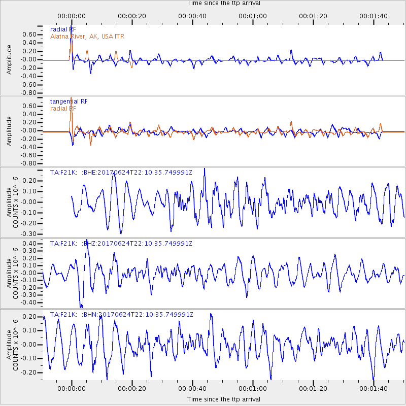
F21K Alatna River, AK, USA - Earthquake Result Viewer
*The percent match for this event was below the threshold and hence no stack was calculated.
| Earthquake location: |
Eastern Honshu, Japan |
| Earthquake latitude/longitude: |
35.8/137.6 |
| Earthquake time(UTC): |
2017/06/24 (175) 22:02:16 GMT |
| Earthquake Depth: |
10 km |
| Earthquake Magnitude: |
5.2 Mww |
| Earthquake Catalog/Contributor: |
NEIC PDE/us |
|
| Network: |
TA USArray Transportable Network (new EarthScope stations) |
| Station: |
F21K Alatna River, AK, USA |
| Lat/Lon: |
67.22 N/153.48 W |
| Elevation: |
597 m |
|
| Distance: |
49.4 deg |
| Az: |
28.577 deg |
| Baz: |
266.786 deg |
| Ray Param: |
$rayparam |
*The percent match for this event was below the threshold and hence was not used in the summary stack. |
|
| Radial Match: |
64.53708 % |
| Radial Bump: |
400 |
| Transverse Match: |
53.05375 % |
| Transverse Bump: |
400 |
| SOD ConfigId: |
13570011 |
| Insert Time: |
2019-04-28 06:45:54.040 +0000 |
| GWidth: |
2.5 |
| Max Bumps: |
400 |
| Tol: |
0.001 |
|
Signal To Noise
| Channel | StoN | STA | LTA |
| TA:F21K: :BHZ:20170624T22:10:35.749991Z | 2.2438962 | 2.3478583E-7 | 1.0463311E-7 |
| TA:F21K: :BHN:20170624T22:10:35.749991Z | 1.2223991 | 1.02407874E-7 | 8.377614E-8 |
| TA:F21K: :BHE:20170624T22:10:35.749991Z | 0.92655003 | 1.16314716E-7 | 1.2553528E-7 |
| Arrivals |
| Ps | |
| PpPs | |
| PsPs/PpSs | |


