You are here: Home > Network List > TA - USArray Transportable Network (new EarthScope stations) Stations List
> Station M31M Drury Creek, Yukon, CA > Earthquake Result Viewer
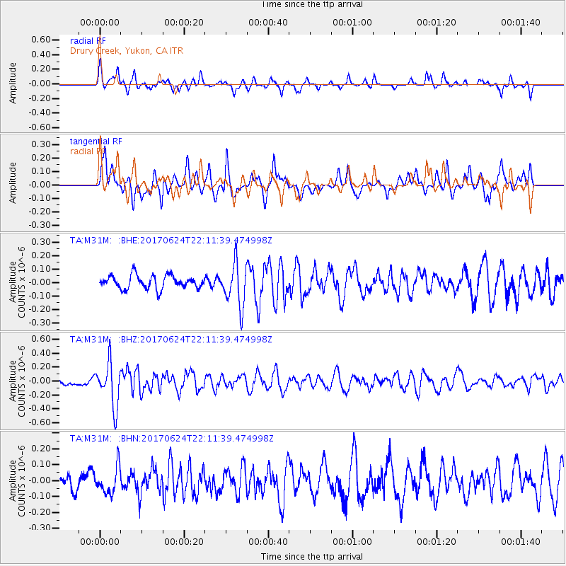
M31M Drury Creek, Yukon, CA - Earthquake Result Viewer
*The percent match for this event was below the threshold and hence no stack was calculated.
| Earthquake location: |
Eastern Honshu, Japan |
| Earthquake latitude/longitude: |
35.8/137.6 |
| Earthquake time(UTC): |
2017/06/24 (175) 22:02:16 GMT |
| Earthquake Depth: |
10 km |
| Earthquake Magnitude: |
5.2 Mww |
| Earthquake Catalog/Contributor: |
NEIC PDE/us |
|
| Network: |
TA USArray Transportable Network (new EarthScope stations) |
| Station: |
M31M Drury Creek, Yukon, CA |
| Lat/Lon: |
62.20 N/134.39 W |
| Elevation: |
639 m |
|
| Distance: |
58.1 deg |
| Az: |
33.481 deg |
| Baz: |
286.982 deg |
| Ray Param: |
$rayparam |
*The percent match for this event was below the threshold and hence was not used in the summary stack. |
|
| Radial Match: |
64.55933 % |
| Radial Bump: |
350 |
| Transverse Match: |
69.14983 % |
| Transverse Bump: |
400 |
| SOD ConfigId: |
13570011 |
| Insert Time: |
2019-04-28 06:46:51.664 +0000 |
| GWidth: |
2.5 |
| Max Bumps: |
400 |
| Tol: |
0.001 |
|
Signal To Noise
| Channel | StoN | STA | LTA |
| TA:M31M: :BHZ:20170624T22:11:39.474998Z | 4.7520976 | 3.1875513E-7 | 6.707672E-8 |
| TA:M31M: :BHN:20170624T22:11:39.474998Z | 1.7427762 | 8.5798725E-8 | 4.9231062E-8 |
| TA:M31M: :BHE:20170624T22:11:39.474998Z | 3.2940683 | 1.6230116E-7 | 4.9270735E-8 |
| Arrivals |
| Ps | |
| PpPs | |
| PsPs/PpSs | |


