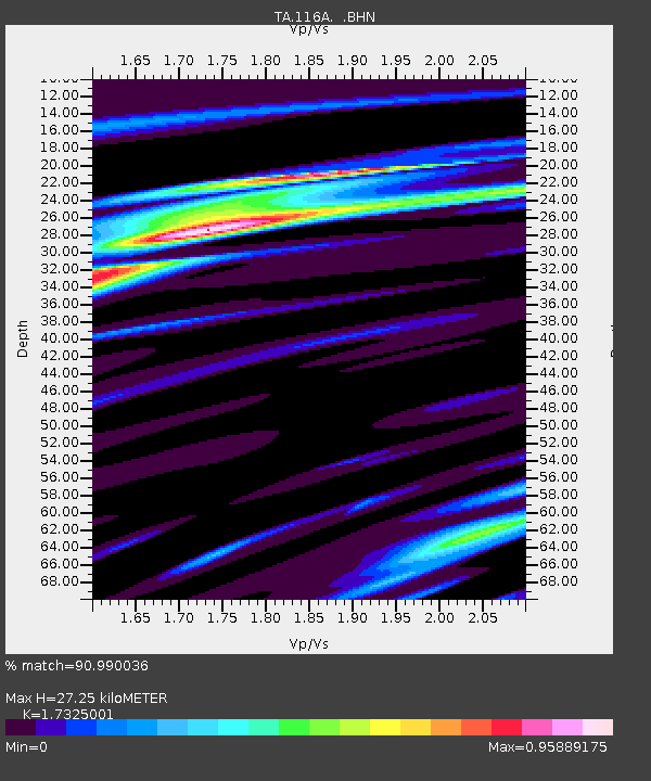
116A Eloy, AZ, USA - Earthquake Result Viewer
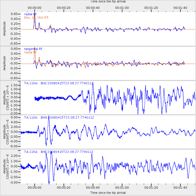
Earthquake location: Andreanof Islands, Aleutian Is.
Earthquake latitude/longitude: 51.9/-179.4
Earthquake time(UTC): 2008/04/15 (106) 22:59:51 GMT
Earthquake Depth: 10 km
Earthquake Magnitude: 6.1 MB, 6.4 MS, 6.4 MW, 6.4 MW
Earthquake Catalog/Contributor: WHDF/NEIC
Network: TA USArray Transportable Network (new EarthScope stations)
Station: 116A Eloy, AZ, USA
Lat/Lon: 32.56 N/111.70 W
Elevation: 477 m
Distance: 51.7 deg
Az: 84.124 deg
Baz: 313.061 deg
Ray Param: 0.06721909
Estimated Moho Depth: 27.25 km
Estimated Crust Vp/Vs: 1.73
Assumed Crust Vp: 6.276 km/s
Estimated Crust Vs: 3.622 km/s
Estimated Crust Poisson's Ratio: 0.25
Radial Match: 90.990036 %
Radial Bump: 400
Transverse Match: 88.10825 %
Transverse Bump: 400
SOD ConfigId: 2504
Insert Time: 2010-03-06 01:18:37.286 +0000
GWidth: 2.5
Max Bumps: 400
Tol: 0.001

Signal To Noise

ChannelStoNSTALTA
TA:116A: :BHN:20080415T23:08:27.774011Z4.0260699.072654E-72.253477E-7
TA:116A: :BHE:20080415T23:08:27.774011Z2.42706924.2455903E-71.7492663E-7
TA:116A: :BHZ:20080415T23:08:27.774011Z3.33418444.198626E-71.2592663E-7
Arrivals
Ps3.4 SECOND
PpPs11 SECOND
PsPs/PpSs15 SECOND