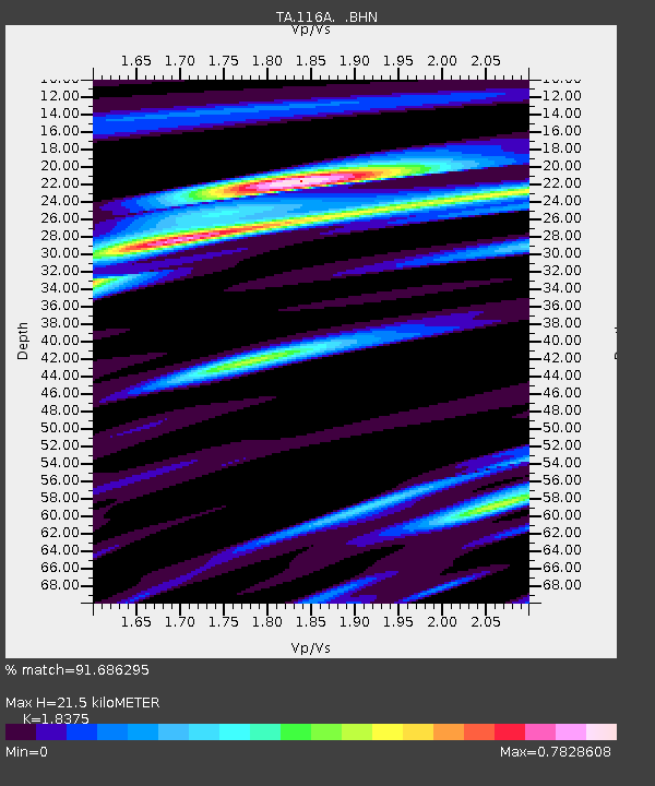
116A Eloy, AZ, USA - Earthquake Result Viewer
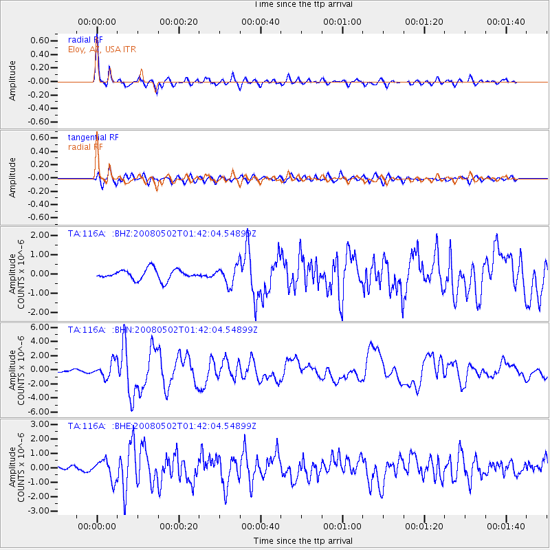
Earthquake location: Andreanof Islands, Aleutian Is.
Earthquake latitude/longitude: 51.9/-177.5
Earthquake time(UTC): 2008/05/02 (123) 01:33:37 GMT
Earthquake Depth: 14 km
Earthquake Magnitude: 6.3 MB, 6.8 MS, 6.6 MW, 6.6 MW
Earthquake Catalog/Contributor: WHDF/NEIC
Network: TA USArray Transportable Network (new EarthScope stations)
Station: 116A Eloy, AZ, USA
Lat/Lon: 32.56 N/111.70 W
Elevation: 477 m
Distance: 50.6 deg
Az: 85.485 deg
Baz: 312.942 deg
Ray Param: 0.06793484
Estimated Moho Depth: 21.5 km
Estimated Crust Vp/Vs: 1.84
Assumed Crust Vp: 6.276 km/s
Estimated Crust Vs: 3.415 km/s
Estimated Crust Poisson's Ratio: 0.29
Radial Match: 91.686295 %
Radial Bump: 400
Transverse Match: 81.50503 %
Transverse Bump: 400
SOD ConfigId: 2504
Insert Time: 2010-03-06 01:18:41.038 +0000
GWidth: 2.5
Max Bumps: 400
Tol: 0.001

Signal To Noise

ChannelStoNSTALTA
TA:116A: :BHN:20080502T01:42:04.54899Z7.3839051.1583326E-61.5687263E-7
TA:116A: :BHE:20080502T01:42:04.54899Z6.5017237.2074147E-71.1085392E-7
TA:116A: :BHZ:20080502T01:42:04.54899Z1.85190564.9642756E-72.6806313E-7
Arrivals
Ps3.0 SECOND
PpPs9.2 SECOND
PsPs/PpSs12 SECOND