You are here: Home > Network List > TA - USArray Transportable Network (new EarthScope stations) Stations List
> Station O17K Koliganek, Bristol Bay, AK, USA > Earthquake Result Viewer
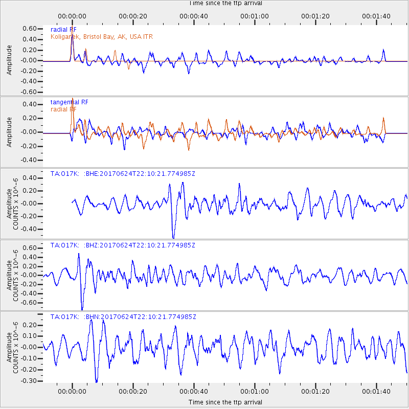
O17K Koliganek, Bristol Bay, AK, USA - Earthquake Result Viewer
*The percent match for this event was below the threshold and hence no stack was calculated.
| Earthquake location: |
Eastern Honshu, Japan |
| Earthquake latitude/longitude: |
35.8/137.6 |
| Earthquake time(UTC): |
2017/06/24 (175) 22:02:16 GMT |
| Earthquake Depth: |
10 km |
| Earthquake Magnitude: |
5.2 Mww |
| Earthquake Catalog/Contributor: |
NEIC PDE/us |
|
| Network: |
TA USArray Transportable Network (new EarthScope stations) |
| Station: |
O17K Koliganek, Bristol Bay, AK, USA |
| Lat/Lon: |
59.77 N/157.09 W |
| Elevation: |
156 m |
|
| Distance: |
47.6 deg |
| Az: |
38.5 deg |
| Baz: |
270.136 deg |
| Ray Param: |
$rayparam |
*The percent match for this event was below the threshold and hence was not used in the summary stack. |
|
| Radial Match: |
64.2415 % |
| Radial Bump: |
339 |
| Transverse Match: |
69.37596 % |
| Transverse Bump: |
400 |
| SOD ConfigId: |
13570011 |
| Insert Time: |
2019-04-28 06:47:04.015 +0000 |
| GWidth: |
2.5 |
| Max Bumps: |
400 |
| Tol: |
0.001 |
|
Signal To Noise
| Channel | StoN | STA | LTA |
| TA:O17K: :BHZ:20170624T22:10:21.774985Z | 3.1974297 | 3.0851564E-7 | 9.6488634E-8 |
| TA:O17K: :BHN:20170624T22:10:21.774985Z | 0.7868861 | 6.024251E-8 | 7.655811E-8 |
| TA:O17K: :BHE:20170624T22:10:21.774985Z | 3.2516375 | 2.3609306E-7 | 7.2607435E-8 |
| Arrivals |
| Ps | |
| PpPs | |
| PsPs/PpSs | |


