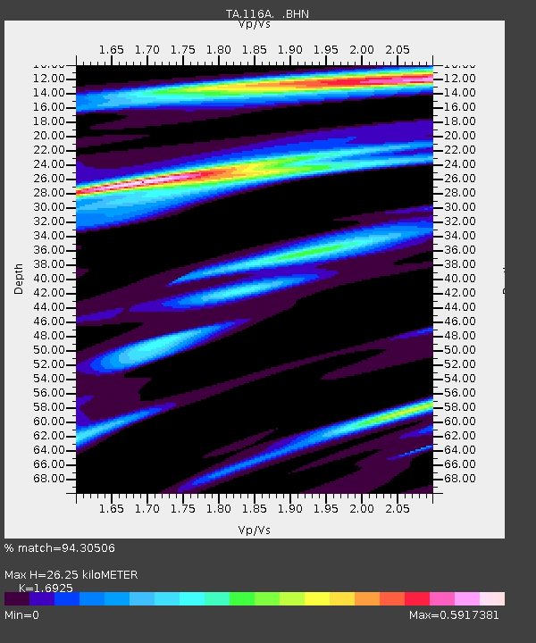
116A Eloy, AZ, USA - Earthquake Result Viewer

Earthquake location: Off East Coast Of Honshu, Japan
Earthquake latitude/longitude: 37.6/142.2
Earthquake time(UTC): 2008/07/19 (201) 02:39:28 GMT
Earthquake Depth: 22 km
Earthquake Magnitude: 6.2 MB, 7.0 MS, 7.0 MW, 6.9 MW
Earthquake Catalog/Contributor: WHDF/NEIC
Network: TA USArray Transportable Network (new EarthScope stations)
Station: 116A Eloy, AZ, USA
Lat/Lon: 32.56 N/111.70 W
Elevation: 477 m
Distance: 82.0 deg
Az: 55.022 deg
Baz: 309.54 deg
Ray Param: 0.04716949
Estimated Moho Depth: 26.25 km
Estimated Crust Vp/Vs: 1.69
Assumed Crust Vp: 6.276 km/s
Estimated Crust Vs: 3.708 km/s
Estimated Crust Poisson's Ratio: 0.23
Radial Match: 94.30506 %
Radial Bump: 400
Transverse Match: 75.34823 %
Transverse Bump: 400
SOD ConfigId: 2504
Insert Time: 2010-03-06 01:18:52.134 +0000
GWidth: 2.5
Max Bumps: 400
Tol: 0.001

Signal To Noise

ChannelStoNSTALTA
TA:116A: :BHN:20080719T02:51:15.525012Z3.21452524.051354E-71.2603273E-7
TA:116A: :BHE:20080719T02:51:15.525012Z1.47609113.9917063E-72.704241E-7
TA:116A: :BHZ:20080719T02:51:15.525012Z1.40093042.2596485E-71.6129628E-7
Arrivals
Ps3.0 SECOND
PpPs11 SECOND
PsPs/PpSs14 SECOND