You are here: Home > Network List > TA - USArray Transportable Network (new EarthScope stations) Stations List
> Station 116A Eloy, AZ, USA > Earthquake Result Viewer
116A Eloy, AZ, USA - Earthquake Result Viewer

| Earthquake location: |
Fiji Islands Region |
| Earthquake latitude/longitude: |
-17.3/-177.3 |
| Earthquake time(UTC): |
2008/07/19 (201) 22:39:52 GMT |
| Earthquake Depth: |
391 km |
| Earthquake Magnitude: |
5.9 MB, 6.4 MW, 6.4 MW |
| Earthquake Catalog/Contributor: |
WHDF/NEIC |
|
| Network: |
TA USArray Transportable Network (new EarthScope stations) |
| Station: |
116A Eloy, AZ, USA |
| Lat/Lon: |
32.56 N/111.70 W |
| Elevation: |
477 m |
|
| Distance: |
80.0 deg |
| Az: |
51.356 deg |
| Baz: |
242.058 deg |
| Ray Param: |
0.04752519 |
| Estimated Moho Depth: |
11.75 km |
| Estimated Crust Vp/Vs: |
1.85 |
| Assumed Crust Vp: |
6.276 km/s |
| Estimated Crust Vs: |
3.397 km/s |
| Estimated Crust Poisson's Ratio: |
0.29 |
|
| Radial Match: |
83.84634 % |
| Radial Bump: |
400 |
| Transverse Match: |
80.117874 % |
| Transverse Bump: |
400 |
| SOD ConfigId: |
2504 |
| Insert Time: |
2010-03-06 01:18:54.652 +0000 |
| GWidth: |
2.5 |
| Max Bumps: |
400 |
| Tol: |
0.001 |
|
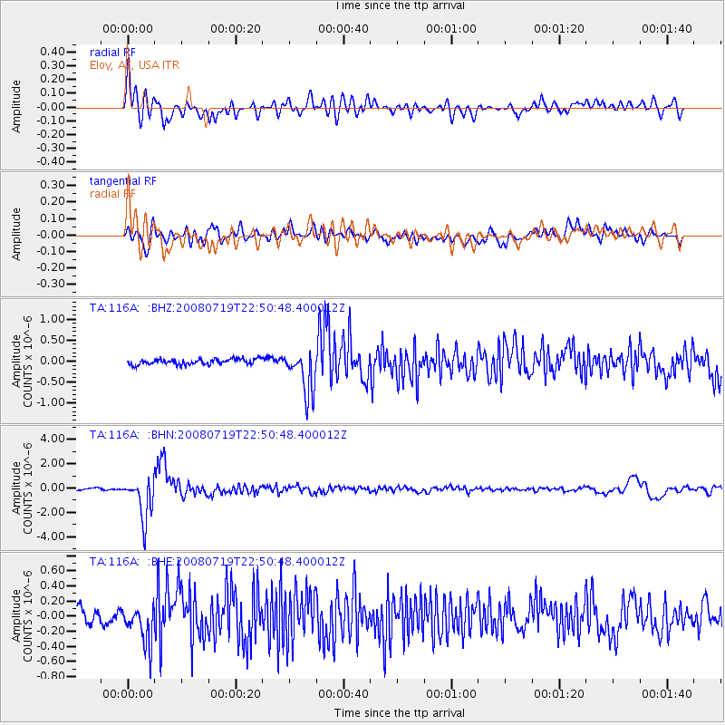
Signal To Noise
| Channel | StoN | STA | LTA |
| TA:116A: :BHN:20080719T22:50:48.400012Z | 12.5704 | 1.6920732E-6 | 1.3460773E-7 |
| TA:116A: :BHE:20080719T22:50:48.400012Z | 1.7651501 | 2.5681072E-7 | 1.4548947E-7 |
| TA:116A: :BHZ:20080719T22:50:48.400012Z | 8.197368 | 5.295141E-7 | 6.459563E-8 |
| Arrivals |
| Ps | 1.6 SECOND |
| PpPs | 5.2 SECOND |
| PsPs/PpSs | 6.8 SECOND |


