You are here: Home > Network List > UW - Pacific Northwest Regional Seismic Network Stations List
> Station UMAT Pilot Rock, OR, USA > Earthquake Result Viewer
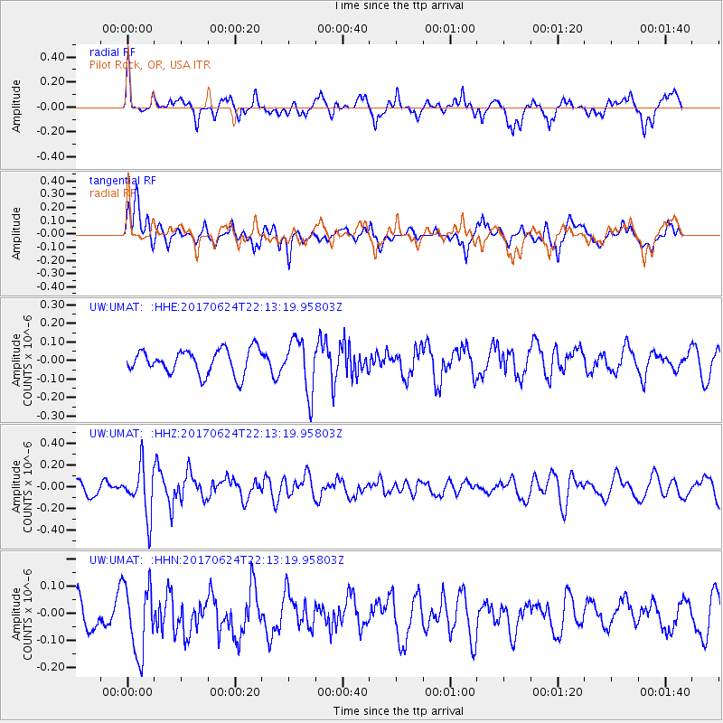
UMAT Pilot Rock, OR, USA - Earthquake Result Viewer
*The percent match for this event was below the threshold and hence no stack was calculated.
| Earthquake location: |
Eastern Honshu, Japan |
| Earthquake latitude/longitude: |
35.8/137.6 |
| Earthquake time(UTC): |
2017/06/24 (175) 22:02:16 GMT |
| Earthquake Depth: |
10 km |
| Earthquake Magnitude: |
5.2 Mww |
| Earthquake Catalog/Contributor: |
NEIC PDE/us |
|
| Network: |
UW Pacific Northwest Regional Seismic Network |
| Station: |
UMAT Pilot Rock, OR, USA |
| Lat/Lon: |
45.29 N/118.96 W |
| Elevation: |
1318 m |
|
| Distance: |
73.8 deg |
| Az: |
45.65 deg |
| Baz: |
304.581 deg |
| Ray Param: |
$rayparam |
*The percent match for this event was below the threshold and hence was not used in the summary stack. |
|
| Radial Match: |
59.24323 % |
| Radial Bump: |
400 |
| Transverse Match: |
57.731354 % |
| Transverse Bump: |
400 |
| SOD ConfigId: |
13570011 |
| Insert Time: |
2019-04-28 06:48:31.840 +0000 |
| GWidth: |
2.5 |
| Max Bumps: |
400 |
| Tol: |
0.001 |
|
Signal To Noise
| Channel | StoN | STA | LTA |
| UW:UMAT: :HHZ:20170624T22:13:19.95803Z | 2.92446 | 2.2803322E-7 | 7.797448E-8 |
| UW:UMAT: :HHN:20170624T22:13:19.95803Z | 1.8264112 | 1.2899058E-7 | 7.062515E-8 |
| UW:UMAT: :HHE:20170624T22:13:19.95803Z | 2.167429 | 1.431363E-7 | 6.6039675E-8 |
| Arrivals |
| Ps | |
| PpPs | |
| PsPs/PpSs | |


