You are here: Home > Network List > TA - USArray Transportable Network (new EarthScope stations) Stations List
> Station 116A Eloy, AZ, USA > Earthquake Result Viewer
116A Eloy, AZ, USA - Earthquake Result Viewer
| Earthquake location: |
Near Coast Of Northern Chile |
| Earthquake latitude/longitude: |
-22.9/-70.4 |
| Earthquake time(UTC): |
2007/11/15 (319) 15:03:08 GMT |
| Earthquake Depth: |
27 km |
| Earthquake Magnitude: |
5.8 MB, 6.1 MW, 5.5 ML |
| Earthquake Catalog/Contributor: |
WHDF/NEIC |
|
| Network: |
TA USArray Transportable Network (new EarthScope stations) |
| Station: |
116A Eloy, AZ, USA |
| Lat/Lon: |
32.56 N/111.70 W |
| Elevation: |
477 m |
|
| Distance: |
67.8 deg |
| Az: |
322.985 deg |
| Baz: |
138.887 deg |
| Ray Param: |
0.056697883 |
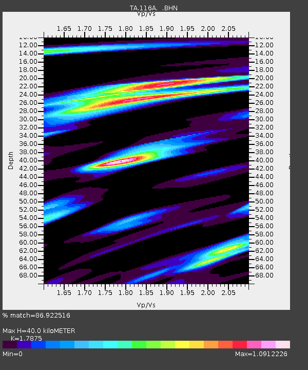
| Estimated Moho Depth: |
40.0 km |
| Estimated Crust Vp/Vs: |
1.79 |
| Assumed Crust Vp: |
6.276 km/s |
| Estimated Crust Vs: |
3.511 km/s |
| Estimated Crust Poisson's Ratio: |
0.27 |
|
| Radial Match: |
86.922516 % |
| Radial Bump: |
400 |
| Transverse Match: |
76.28576 % |
| Transverse Bump: |
400 |
| SOD ConfigId: |
2564 |
| Insert Time: |
2010-03-06 01:19:35.841 +0000 |
| GWidth: |
2.5 |
| Max Bumps: |
400 |
| Tol: |
0.001 |
|
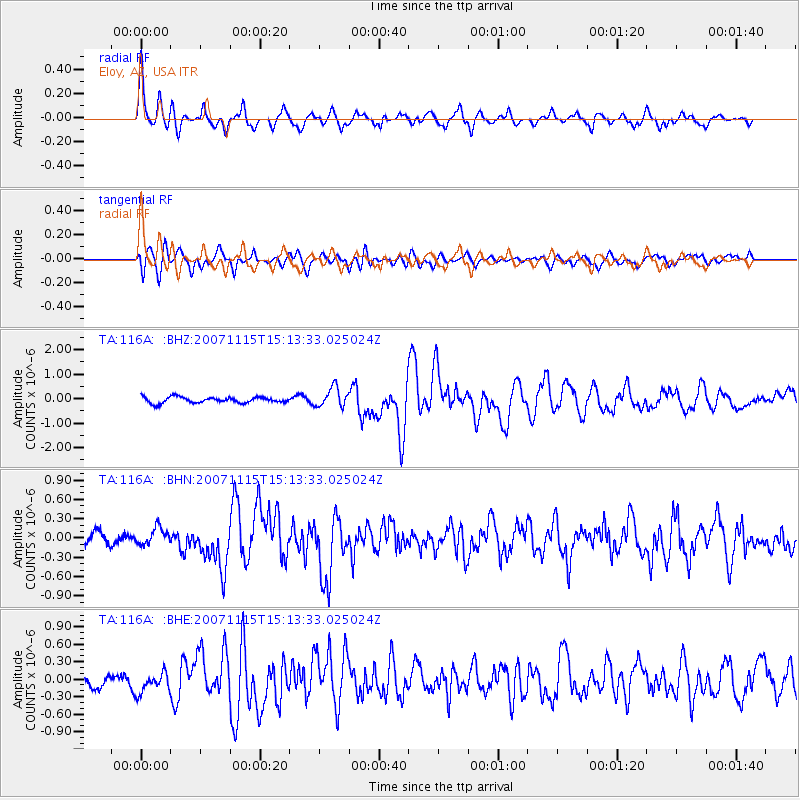
Signal To Noise
| Channel | StoN | STA | LTA |
| TA:116A: :BHN:20071115T15:13:33.025024Z | 1.0356476 | 1.3614046E-7 | 1.3145443E-7 |
| TA:116A: :BHE:20071115T15:13:33.025024Z | 1.641713 | 1.888379E-7 | 1.1502491E-7 |
| TA:116A: :BHZ:20071115T15:13:33.025024Z | 3.2697873 | 3.89108E-7 | 1.19001015E-7 |
| Arrivals |
| Ps | 5.2 SECOND |
| PpPs | 17 SECOND |
| PsPs/PpSs | 22 SECOND |


