You are here: Home > Network List > TA - USArray Transportable Network (new EarthScope stations) Stations List
> Station 116A Eloy, AZ, USA > Earthquake Result Viewer
116A Eloy, AZ, USA - Earthquake Result Viewer
| Earthquake location: |
Tonga Islands |
| Earthquake latitude/longitude: |
-17.5/-174.3 |
| Earthquake time(UTC): |
2007/08/26 (238) 12:37:31 GMT |
| Earthquake Depth: |
127 km |
| Earthquake Magnitude: |
5.9 MB, 6.1 MW |
| Earthquake Catalog/Contributor: |
WHDF/NEIC |
|
| Network: |
TA USArray Transportable Network (new EarthScope stations) |
| Station: |
116A Eloy, AZ, USA |
| Lat/Lon: |
32.56 N/111.70 W |
| Elevation: |
477 m |
|
| Distance: |
77.8 deg |
| Az: |
50.1 deg |
| Baz: |
240.131 deg |
| Ray Param: |
0.04975235 |
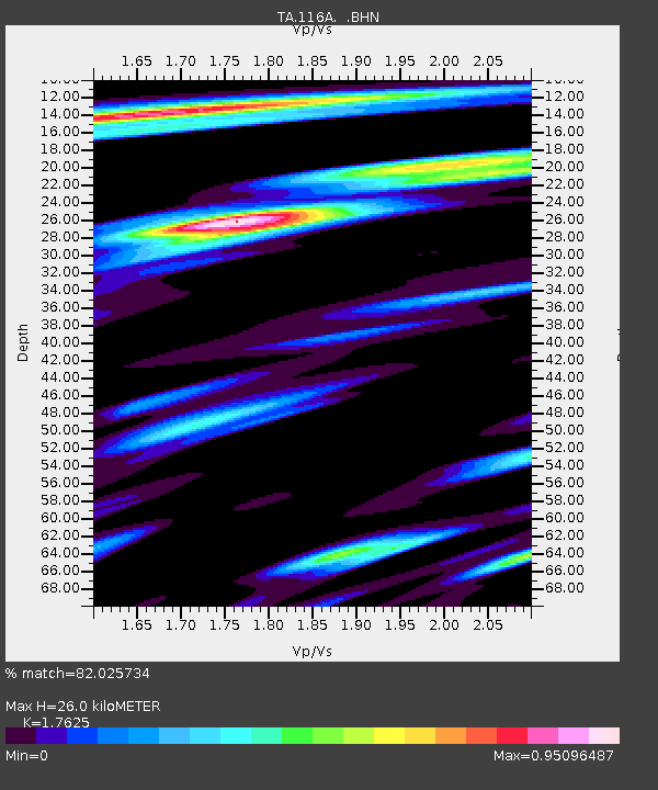
| Estimated Moho Depth: |
26.0 km |
| Estimated Crust Vp/Vs: |
1.76 |
| Assumed Crust Vp: |
6.276 km/s |
| Estimated Crust Vs: |
3.561 km/s |
| Estimated Crust Poisson's Ratio: |
0.26 |
|
| Radial Match: |
82.025734 % |
| Radial Bump: |
400 |
| Transverse Match: |
66.27951 % |
| Transverse Bump: |
400 |
| SOD ConfigId: |
2564 |
| Insert Time: |
2010-03-06 01:19:53.288 +0000 |
| GWidth: |
2.5 |
| Max Bumps: |
400 |
| Tol: |
0.001 |
|
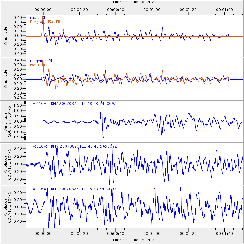
Signal To Noise
| Channel | StoN | STA | LTA |
| TA:116A: :BHN:20070826T12:48:43.549009Z | 5.3449965 | 1.7422136E-7 | 3.2595224E-8 |
| TA:116A: :BHE:20070826T12:48:43.549009Z | 4.1432123 | 2.5966995E-7 | 6.267358E-8 |
| TA:116A: :BHZ:20070826T12:48:43.549009Z | 12.606482 | 7.94599E-7 | 6.303099E-8 |
| Arrivals |
| Ps | 3.3 SECOND |
| PpPs | 11 SECOND |
| PsPs/PpSs | 14 SECOND |


