You are here: Home > Network List > TA - USArray Transportable Network (new EarthScope stations) Stations List
> Station 116A Eloy, AZ, USA > Earthquake Result Viewer
116A Eloy, AZ, USA - Earthquake Result Viewer

| Earthquake location: |
Near East Coast Of Kamchatka |
| Earthquake latitude/longitude: |
55.6/161.7 |
| Earthquake time(UTC): |
2006/08/17 (229) 11:11:35 GMT |
| Earthquake Depth: |
55 km |
| Earthquake Magnitude: |
6.1 MB, 5.7 MW, 5.7 MW |
| Earthquake Catalog/Contributor: |
WHDF/NEIC |
|
| Network: |
TA USArray Transportable Network (new EarthScope stations) |
| Station: |
116A Eloy, AZ, USA |
| Lat/Lon: |
32.56 N/111.70 W |
| Elevation: |
477 m |
|
| Distance: |
62.0 deg |
| Az: |
72.688 deg |
| Baz: |
320.106 deg |
| Ray Param: |
0.060386553 |
| Estimated Moho Depth: |
33.0 km |
| Estimated Crust Vp/Vs: |
1.60 |
| Assumed Crust Vp: |
6.276 km/s |
| Estimated Crust Vs: |
3.922 km/s |
| Estimated Crust Poisson's Ratio: |
0.18 |
|
| Radial Match: |
83.844765 % |
| Radial Bump: |
400 |
| Transverse Match: |
78.004486 % |
| Transverse Bump: |
400 |
| SOD ConfigId: |
2564 |
| Insert Time: |
2010-03-06 01:20:47.002 +0000 |
| GWidth: |
2.5 |
| Max Bumps: |
400 |
| Tol: |
0.001 |
|
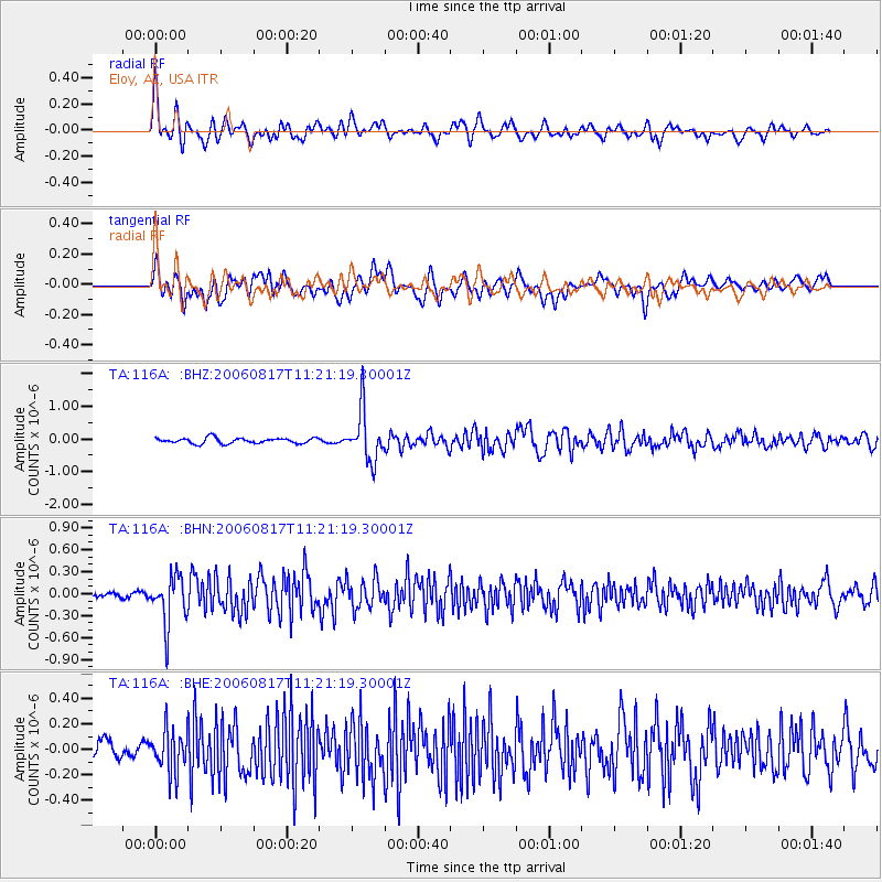
Signal To Noise
| Channel | StoN | STA | LTA |
| TA:116A: :BHN:20060817T11:21:19.30001Z | 7.7328506 | 3.295093E-7 | 4.261162E-8 |
| TA:116A: :BHE:20060817T11:21:19.30001Z | 2.437976 | 1.6577906E-7 | 6.799865E-8 |
| TA:116A: :BHZ:20060817T11:21:19.30001Z | 9.294512 | 7.6960805E-7 | 8.280242E-8 |
| Arrivals |
| Ps | 3.3 SECOND |
| PpPs | 13 SECOND |
| PsPs/PpSs | 16 SECOND |


