You are here: Home > Network List > TA - USArray Transportable Network (new EarthScope stations) Stations List
> Station 116A Eloy, AZ, USA > Earthquake Result Viewer
116A Eloy, AZ, USA - Earthquake Result Viewer
| Earthquake location: |
Kuril Islands |
| Earthquake latitude/longitude: |
46.5/153.2 |
| Earthquake time(UTC): |
2006/10/01 (274) 09:06:02 GMT |
| Earthquake Depth: |
19 km |
| Earthquake Magnitude: |
6.1 MB, 6.4 MS, 6.6 MW, 6.5 MW |
| Earthquake Catalog/Contributor: |
WHDF/NEIC |
|
| Network: |
TA USArray Transportable Network (new EarthScope stations) |
| Station: |
116A Eloy, AZ, USA |
| Lat/Lon: |
32.56 N/111.70 W |
| Elevation: |
477 m |
|
| Distance: |
70.4 deg |
| Az: |
63.249 deg |
| Baz: |
313.04 deg |
| Ray Param: |
0.05499901 |
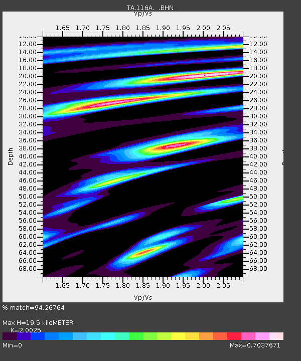
| Estimated Moho Depth: |
19.5 km |
| Estimated Crust Vp/Vs: |
2.00 |
| Assumed Crust Vp: |
6.276 km/s |
| Estimated Crust Vs: |
3.134 km/s |
| Estimated Crust Poisson's Ratio: |
0.33 |
|
| Radial Match: |
94.26764 % |
| Radial Bump: |
400 |
| Transverse Match: |
77.565544 % |
| Transverse Bump: |
400 |
| SOD ConfigId: |
2665 |
| Insert Time: |
2010-03-06 01:20:58.222 +0000 |
| GWidth: |
2.5 |
| Max Bumps: |
400 |
| Tol: |
0.001 |
|

Signal To Noise
| Channel | StoN | STA | LTA |
| TA:116A: :BHN:20061001T09:16:43.749016Z | 2.8301263 | 1.9308978E-7 | 6.8226555E-8 |
| TA:116A: :BHE:20061001T09:16:43.749016Z | 1.1423061 | 1.3749104E-7 | 1.203627E-7 |
| TA:116A: :BHZ:20061001T09:16:43.749016Z | 5.6949296 | 6.522973E-7 | 1.1454001E-7 |
| Arrivals |
| Ps | 3.2 SECOND |
| PpPs | 9.0 SECOND |
| PsPs/PpSs | 12 SECOND |


