You are here: Home > Network List > TA - USArray Transportable Network (new EarthScope stations) Stations List
> Station G23K Bananza Creek, AK, USA > Earthquake Result Viewer
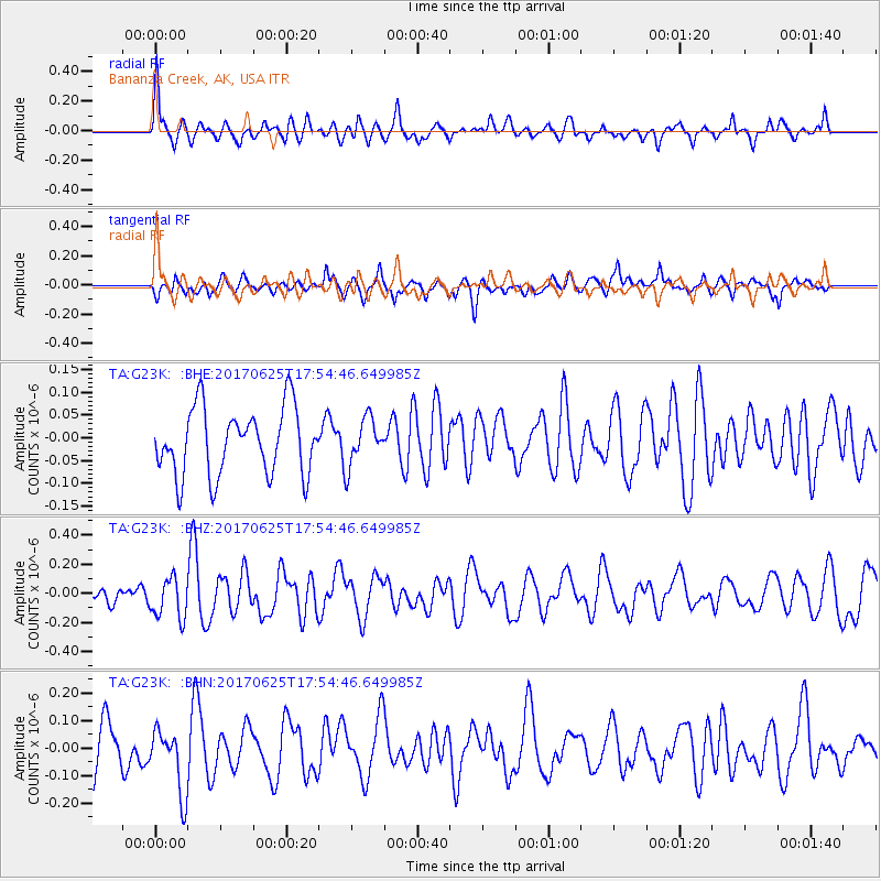
G23K Bananza Creek, AK, USA - Earthquake Result Viewer
*The percent match for this event was below the threshold and hence no stack was calculated.
| Earthquake location: |
Fiji Islands Region |
| Earthquake latitude/longitude: |
-19.7/-176.5 |
| Earthquake time(UTC): |
2017/06/25 (176) 17:42:30 GMT |
| Earthquake Depth: |
38 km |
| Earthquake Magnitude: |
6.2 Mww |
| Earthquake Catalog/Contributor: |
NEIC PDE/us |
|
| Network: |
TA USArray Transportable Network (new EarthScope stations) |
| Station: |
G23K Bananza Creek, AK, USA |
| Lat/Lon: |
66.71 N/150.02 W |
| Elevation: |
746 m |
|
| Distance: |
88.4 deg |
| Az: |
10.201 deg |
| Baz: |
204.82 deg |
| Ray Param: |
$rayparam |
*The percent match for this event was below the threshold and hence was not used in the summary stack. |
|
| Radial Match: |
68.52859 % |
| Radial Bump: |
347 |
| Transverse Match: |
59.080853 % |
| Transverse Bump: |
400 |
| SOD ConfigId: |
13570011 |
| Insert Time: |
2019-04-28 06:54:56.291 +0000 |
| GWidth: |
2.5 |
| Max Bumps: |
400 |
| Tol: |
0.001 |
|
Signal To Noise
| Channel | StoN | STA | LTA |
| TA:G23K: :BHZ:20170625T17:54:46.649985Z | 3.0645537 | 1.38637E-7 | 4.5238885E-8 |
| TA:G23K: :BHN:20170625T17:54:46.649985Z | 1.3783331 | 1.2189386E-7 | 8.843571E-8 |
| TA:G23K: :BHE:20170625T17:54:46.649985Z | 0.7035529 | 5.1467488E-8 | 7.3153686E-8 |
| Arrivals |
| Ps | |
| PpPs | |
| PsPs/PpSs | |


