You are here: Home > Network List > TA - USArray Transportable Network (new EarthScope stations) Stations List
> Station I23K Minto, Yukon-Koyukuk, AK, USA > Earthquake Result Viewer
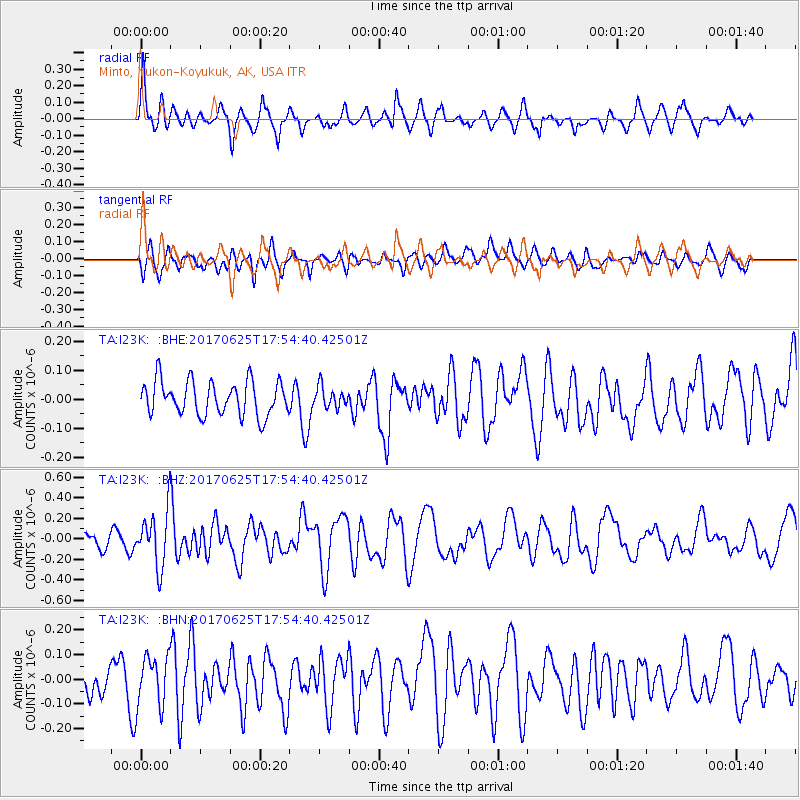
I23K Minto, Yukon-Koyukuk, AK, USA - Earthquake Result Viewer
*The percent match for this event was below the threshold and hence no stack was calculated.
| Earthquake location: |
Fiji Islands Region |
| Earthquake latitude/longitude: |
-19.7/-176.5 |
| Earthquake time(UTC): |
2017/06/25 (176) 17:42:30 GMT |
| Earthquake Depth: |
38 km |
| Earthquake Magnitude: |
6.2 Mww |
| Earthquake Catalog/Contributor: |
NEIC PDE/us |
|
| Network: |
TA USArray Transportable Network (new EarthScope stations) |
| Station: |
I23K Minto, Yukon-Koyukuk, AK, USA |
| Lat/Lon: |
65.15 N/149.36 W |
| Elevation: |
149 m |
|
| Distance: |
87.1 deg |
| Az: |
11.115 deg |
| Baz: |
205.461 deg |
| Ray Param: |
$rayparam |
*The percent match for this event was below the threshold and hence was not used in the summary stack. |
|
| Radial Match: |
72.88259 % |
| Radial Bump: |
400 |
| Transverse Match: |
57.31759 % |
| Transverse Bump: |
400 |
| SOD ConfigId: |
13570011 |
| Insert Time: |
2019-04-28 06:55:05.894 +0000 |
| GWidth: |
2.5 |
| Max Bumps: |
400 |
| Tol: |
0.001 |
|
Signal To Noise
| Channel | StoN | STA | LTA |
| TA:I23K: :BHZ:20170625T17:54:40.42501Z | 4.7746525 | 2.727844E-7 | 5.7131782E-8 |
| TA:I23K: :BHN:20170625T17:54:40.42501Z | 1.1837119 | 1.0177608E-7 | 8.598045E-8 |
| TA:I23K: :BHE:20170625T17:54:40.42501Z | 0.60062134 | 3.5365634E-8 | 5.8881746E-8 |
| Arrivals |
| Ps | |
| PpPs | |
| PsPs/PpSs | |


