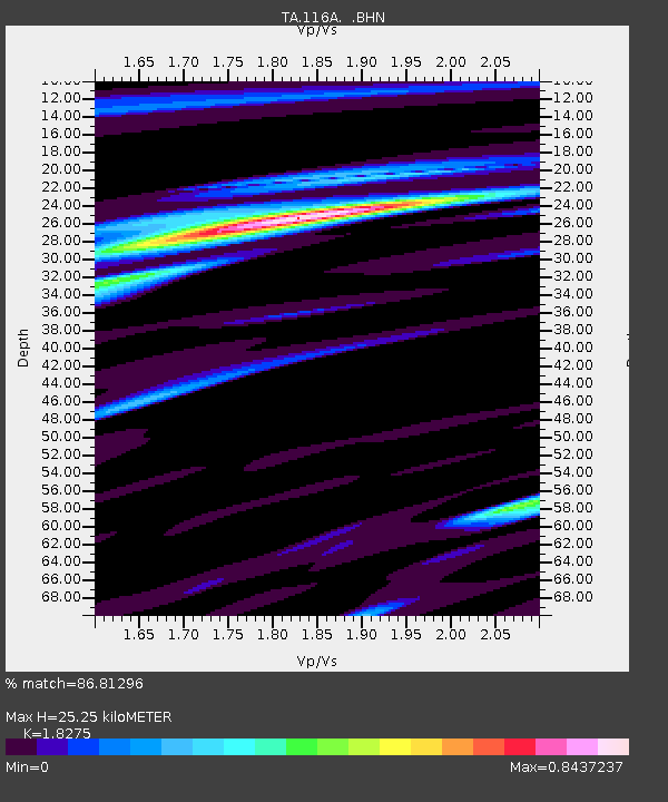
116A Eloy, AZ, USA - Earthquake Result Viewer

Earthquake location: Andreanof Islands, Aleutian Is.
Earthquake latitude/longitude: 51.2/-179.3
Earthquake time(UTC): 2006/07/08 (189) 20:40:00 GMT
Earthquake Depth: 22 km
Earthquake Magnitude: 6.2 MB, 6.4 MS, 6.6 MW, 6.6 MW
Earthquake Catalog/Contributor: WHDF/NEIC
Network: TA USArray Transportable Network (new EarthScope stations)
Station: 116A Eloy, AZ, USA
Lat/Lon: 32.56 N/111.70 W
Elevation: 477 m
Distance: 51.8 deg
Az: 83.655 deg
Baz: 312.246 deg
Ray Param: 0.067161456
Estimated Moho Depth: 25.25 km
Estimated Crust Vp/Vs: 1.83
Assumed Crust Vp: 6.276 km/s
Estimated Crust Vs: 3.434 km/s
Estimated Crust Poisson's Ratio: 0.29
Radial Match: 86.81296 %
Radial Bump: 400
Transverse Match: 74.13717 %
Transverse Bump: 400
SOD ConfigId: 2665
Insert Time: 2010-03-06 01:21:12.314 +0000
GWidth: 2.5
Max Bumps: 400
Tol: 0.001

Signal To Noise

ChannelStoNSTALTA
TA:116A: :BHN:20060708T20:48:36.00002Z1.83910081.6247694E-78.834586E-8
TA:116A: :BHE:20060708T20:48:36.00002Z1.52563732.0459062E-71.3410174E-7
TA:116A: :BHZ:20060708T20:48:36.00002Z2.60390733.7031887E-71.4221662E-7
Arrivals
Ps3.5 SECOND
PpPs11 SECOND
PsPs/PpSs14 SECOND