You are here: Home > Network List > TA - USArray Transportable Network (new EarthScope stations) Stations List
> Station 116A Eloy, AZ, USA > Earthquake Result Viewer
116A Eloy, AZ, USA - Earthquake Result Viewer
| Earthquake location: |
Eastern Siberia, Russia |
| Earthquake latitude/longitude: |
60.5/165.8 |
| Earthquake time(UTC): |
2006/04/21 (111) 04:32:43 GMT |
| Earthquake Depth: |
9.0 km |
| Earthquake Magnitude: |
6.3 MB, 5.6 MS, 6.1 MW, 6.1 ME |
| Earthquake Catalog/Contributor: |
WHDF/NEIC |
|
| Network: |
TA USArray Transportable Network (new EarthScope stations) |
| Station: |
116A Eloy, AZ, USA |
| Lat/Lon: |
32.56 N/111.70 W |
| Elevation: |
477 m |
|
| Distance: |
58.7 deg |
| Az: |
78.599 deg |
| Baz: |
324.966 deg |
| Ray Param: |
0.06270637 |
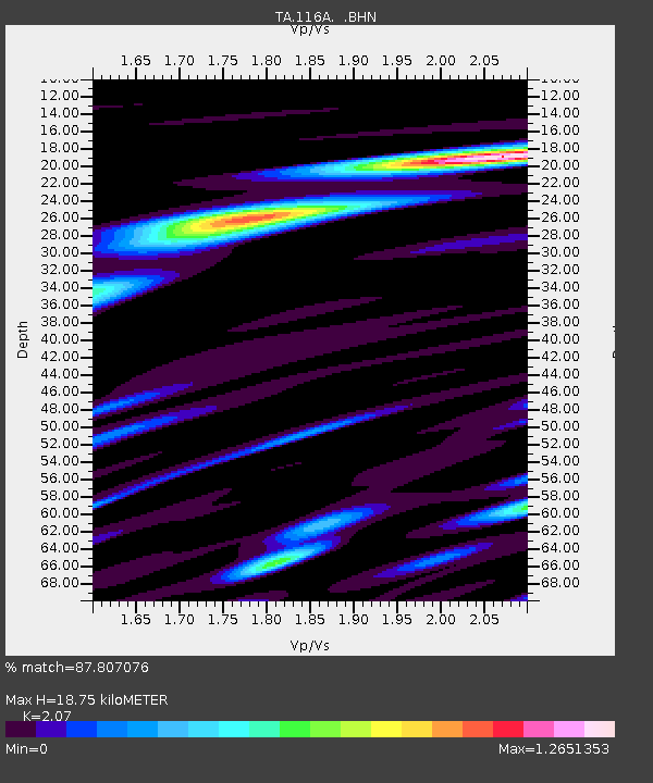
| Estimated Moho Depth: |
18.75 km |
| Estimated Crust Vp/Vs: |
2.07 |
| Assumed Crust Vp: |
6.276 km/s |
| Estimated Crust Vs: |
3.032 km/s |
| Estimated Crust Poisson's Ratio: |
0.35 |
|
| Radial Match: |
87.807076 % |
| Radial Bump: |
400 |
| Transverse Match: |
84.62102 % |
| Transverse Bump: |
400 |
| SOD ConfigId: |
2669 |
| Insert Time: |
2010-03-06 01:21:33.107 +0000 |
| GWidth: |
2.5 |
| Max Bumps: |
400 |
| Tol: |
0.001 |
|
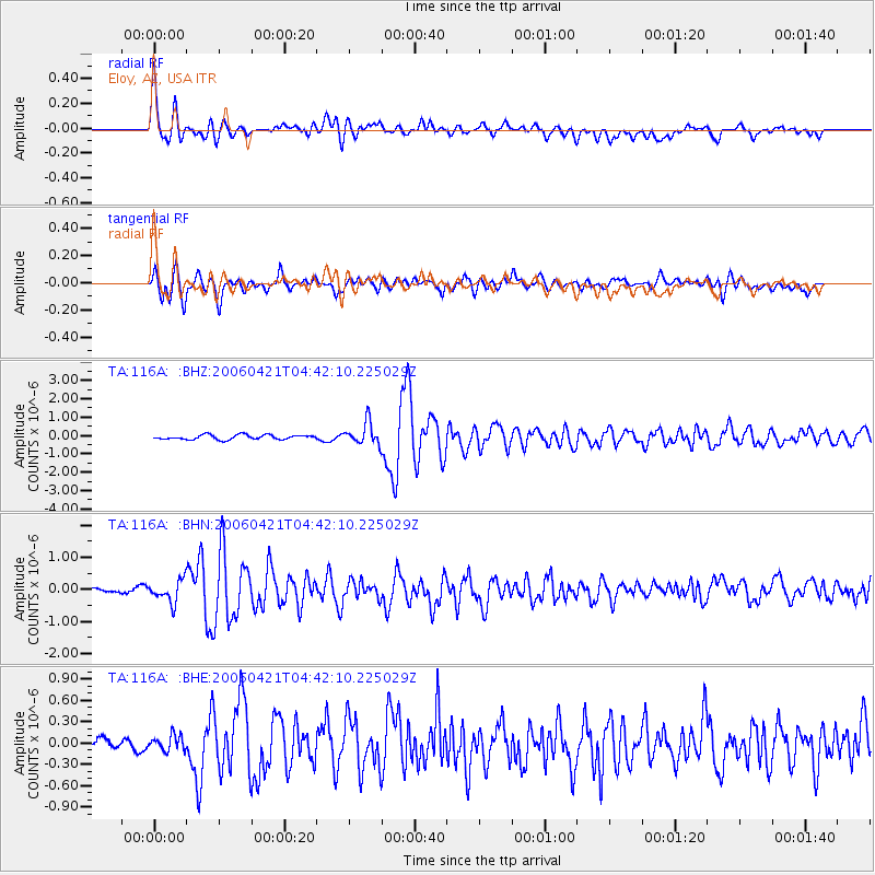
Signal To Noise
| Channel | StoN | STA | LTA |
| TA:116A: :BHN:20060421T04:42:10.225029Z | 3.165479 | 3.3844722E-7 | 1.0691817E-7 |
| TA:116A: :BHE:20060421T04:42:10.225029Z | 1.1726155 | 1.06168E-7 | 9.053948E-8 |
| TA:116A: :BHZ:20060421T04:42:10.225029Z | 4.8208327 | 6.056328E-7 | 1.2562825E-7 |
| Arrivals |
| Ps | 3.3 SECOND |
| PpPs | 8.8 SECOND |
| PsPs/PpSs | 12 SECOND |


