You are here: Home > Network List > TA - USArray Transportable Network (new EarthScope stations) Stations List
> Station 116A Eloy, AZ, USA > Earthquake Result Viewer
116A Eloy, AZ, USA - Earthquake Result Viewer
| Earthquake location: |
Kermadec Islands Region |
| Earthquake latitude/longitude: |
-29.6/-176.8 |
| Earthquake time(UTC): |
2006/03/31 (090) 13:21:00 GMT |
| Earthquake Depth: |
17 km |
| Earthquake Magnitude: |
5.9 MB, 6.7 MS, 6.5 MW, 6.5 MW |
| Earthquake Catalog/Contributor: |
WHDF/NEIC |
|
| Network: |
TA USArray Transportable Network (new EarthScope stations) |
| Station: |
116A Eloy, AZ, USA |
| Lat/Lon: |
32.56 N/111.70 W |
| Elevation: |
477 m |
|
| Distance: |
87.4 deg |
| Az: |
50.076 deg |
| Baz: |
232.266 deg |
| Ray Param: |
0.043369003 |
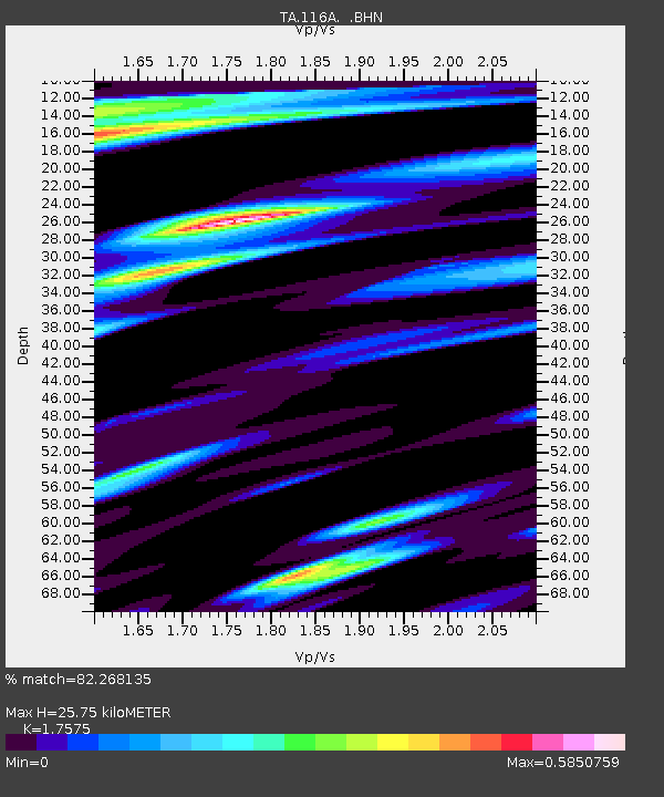
| Estimated Moho Depth: |
25.75 km |
| Estimated Crust Vp/Vs: |
1.76 |
| Assumed Crust Vp: |
6.276 km/s |
| Estimated Crust Vs: |
3.571 km/s |
| Estimated Crust Poisson's Ratio: |
0.26 |
|
| Radial Match: |
82.268135 % |
| Radial Bump: |
400 |
| Transverse Match: |
80.26169 % |
| Transverse Bump: |
400 |
| SOD ConfigId: |
132717 |
| Insert Time: |
2010-03-06 01:21:34.840 +0000 |
| GWidth: |
2.5 |
| Max Bumps: |
400 |
| Tol: |
0.001 |
|

Signal To Noise
| Channel | StoN | STA | LTA |
| TA:116A: :BHN:20060331T13:33:14.825027Z | 1.5719908 | 1.268447E-7 | 8.069048E-8 |
| TA:116A: :BHE:20060331T13:33:14.825027Z | 1.1099098 | 1.238232E-7 | 1.115615E-7 |
| TA:116A: :BHZ:20060331T13:33:14.825027Z | 2.4046676 | 1.8668254E-7 | 7.763341E-8 |
| Arrivals |
| Ps | 3.2 SECOND |
| PpPs | 11 SECOND |
| PsPs/PpSs | 14 SECOND |


