You are here: Home > Network List > TA - USArray Transportable Network (new EarthScope stations) Stations List
> Station 116A Eloy, AZ, USA > Earthquake Result Viewer
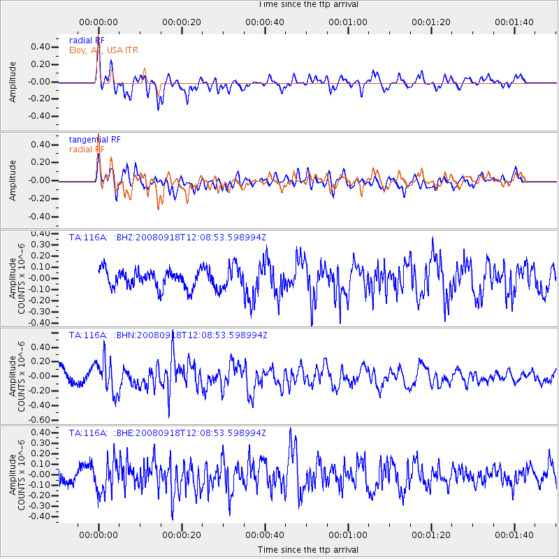
116A Eloy, AZ, USA - Earthquake Result Viewer
*The percent match for this event was below the threshold and hence no stack was calculated.
| Earthquake location: |
Near East Coast Of Kamchatka |
| Earthquake latitude/longitude: |
51.9/158.4 |
| Earthquake time(UTC): |
2008/09/18 (262) 11:58:50 GMT |
| Earthquake Depth: |
67 km |
| Earthquake Magnitude: |
5.7 MB, 5.9 MW, 5.8 MW |
| Earthquake Catalog/Contributor: |
WHDF/NEIC |
|
| Network: |
TA USArray Transportable Network (new EarthScope stations) |
| Station: |
116A Eloy, AZ, USA |
| Lat/Lon: |
32.56 N/111.70 W |
| Elevation: |
477 m |
|
| Distance: |
65.1 deg |
| Az: |
68.614 deg |
| Baz: |
316.928 deg |
| Ray Param: |
$rayparam |
*The percent match for this event was below the threshold and hence was not used in the summary stack. |
|
| Radial Match: |
65.80401 % |
| Radial Bump: |
400 |
| Transverse Match: |
63.54169 % |
| Transverse Bump: |
400 |
| SOD ConfigId: |
2504 |
| Insert Time: |
2010-03-06 01:21:46.598 +0000 |
| GWidth: |
2.5 |
| Max Bumps: |
400 |
| Tol: |
0.001 |
|
Signal To Noise
| Channel | StoN | STA | LTA |
| TA:116A: :BHN:20080918T12:08:53.598994Z | 2.3260348 | 2.3180553E-7 | 9.965695E-8 |
| TA:116A: :BHE:20080918T12:08:53.598994Z | 1.6879735 | 1.4470082E-7 | 8.572459E-8 |
| TA:116A: :BHZ:20080918T12:08:53.598994Z | 1.3396256 | 1.03098415E-7 | 7.696062E-8 |
| Arrivals |
| Ps | |
| PpPs | |
| PsPs/PpSs | |


