You are here: Home > Network List > TA - USArray Transportable Network (new EarthScope stations) Stations List
> Station 116A Eloy, AZ, USA > Earthquake Result Viewer
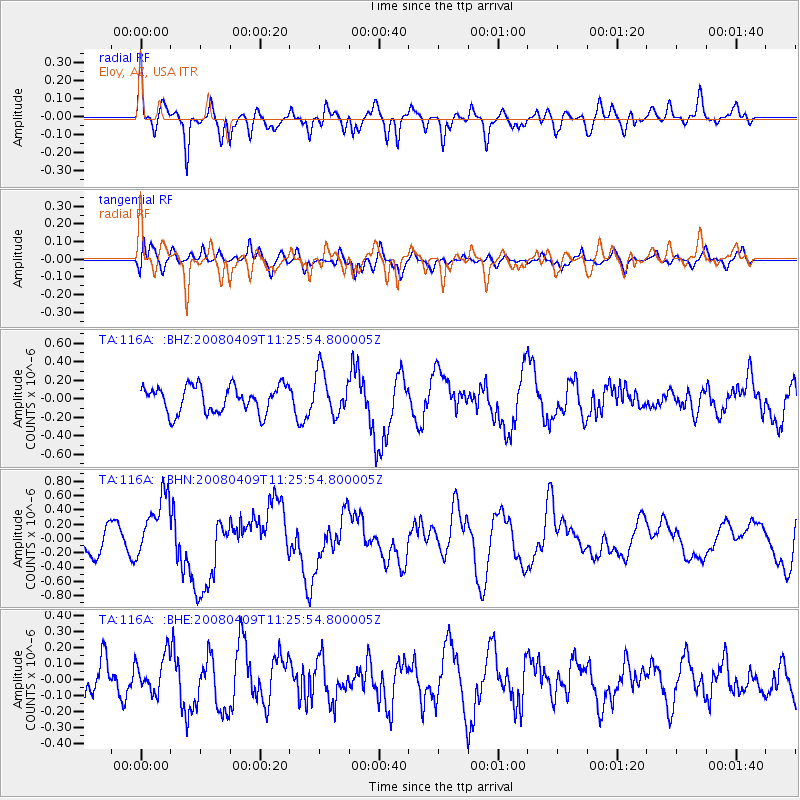
116A Eloy, AZ, USA - Earthquake Result Viewer
*The percent match for this event was below the threshold and hence no stack was calculated.
| Earthquake location: |
Loyalty Islands |
| Earthquake latitude/longitude: |
-20.2/168.9 |
| Earthquake time(UTC): |
2008/04/09 (100) 11:13:17 GMT |
| Earthquake Depth: |
13 km |
| Earthquake Magnitude: |
5.6 MB, 6.3 MS, 6.4 MW, 6.3 MW |
| Earthquake Catalog/Contributor: |
WHDF/NEIC |
|
| Network: |
TA USArray Transportable Network (new EarthScope stations) |
| Station: |
116A Eloy, AZ, USA |
| Lat/Lon: |
32.56 N/111.70 W |
| Elevation: |
477 m |
|
| Distance: |
92.2 deg |
| Az: |
56.174 deg |
| Baz: |
247.539 deg |
| Ray Param: |
$rayparam |
*The percent match for this event was below the threshold and hence was not used in the summary stack. |
|
| Radial Match: |
73.78388 % |
| Radial Bump: |
400 |
| Transverse Match: |
41.90136 % |
| Transverse Bump: |
400 |
| SOD ConfigId: |
2504 |
| Insert Time: |
2010-03-06 01:21:50.823 +0000 |
| GWidth: |
2.5 |
| Max Bumps: |
400 |
| Tol: |
0.001 |
|
Signal To Noise
| Channel | StoN | STA | LTA |
| TA:116A: :BHN:20080409T11:25:54.800005Z | 2.7632034 | 4.3761284E-7 | 1.5837155E-7 |
| TA:116A: :BHE:20080409T11:25:54.800005Z | 1.1444143 | 1.1700194E-7 | 1.02237394E-7 |
| TA:116A: :BHZ:20080409T11:25:54.800005Z | 1.6472762 | 2.3499811E-7 | 1.426586E-7 |
| Arrivals |
| Ps | |
| PpPs | |
| PsPs/PpSs | |


