You are here: Home > Network List > TA - USArray Transportable Network (new EarthScope stations) Stations List
> Station 116A Eloy, AZ, USA > Earthquake Result Viewer
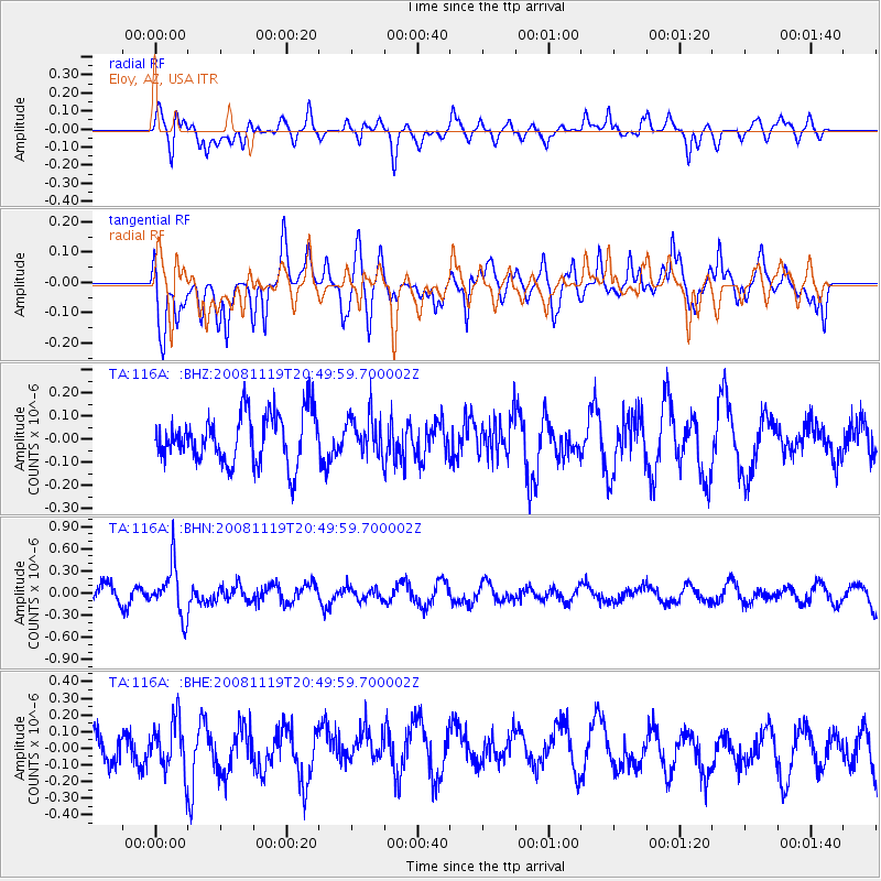
116A Eloy, AZ, USA - Earthquake Result Viewer
*The percent match for this event was below the threshold and hence no stack was calculated.
| Earthquake location: |
South Of Fiji Islands |
| Earthquake latitude/longitude: |
-22.2/-179.7 |
| Earthquake time(UTC): |
2008/11/19 (324) 20:38:58 GMT |
| Earthquake Depth: |
596 km |
| Earthquake Magnitude: |
5.8 MW, 5.2 MB, 5.8 MW |
| Earthquake Catalog/Contributor: |
WHDF/NEIC |
|
| Network: |
TA USArray Transportable Network (new EarthScope stations) |
| Station: |
116A Eloy, AZ, USA |
| Lat/Lon: |
32.56 N/111.70 W |
| Elevation: |
477 m |
|
| Distance: |
84.7 deg |
| Az: |
51.848 deg |
| Baz: |
239.679 deg |
| Ray Param: |
$rayparam |
*The percent match for this event was below the threshold and hence was not used in the summary stack. |
|
| Radial Match: |
45.635162 % |
| Radial Bump: |
374 |
| Transverse Match: |
64.50283 % |
| Transverse Bump: |
400 |
| SOD ConfigId: |
2658 |
| Insert Time: |
2010-03-06 01:22:13.549 +0000 |
| GWidth: |
2.5 |
| Max Bumps: |
400 |
| Tol: |
0.001 |
|
Signal To Noise
| Channel | StoN | STA | LTA |
| TA:116A: :BHN:20081119T20:49:59.700002Z | 2.0715547 | 3.367833E-7 | 1.6257515E-7 |
| TA:116A: :BHE:20081119T20:49:59.700002Z | 1.7366898 | 1.5517158E-7 | 8.934905E-8 |
| TA:116A: :BHZ:20081119T20:49:59.700002Z | 0.78645205 | 8.447951E-8 | 1.07418515E-7 |
| Arrivals |
| Ps | |
| PpPs | |
| PsPs/PpSs | |


