You are here: Home > Network List > AK - Alaska Regional Network Stations List
> Station MDM Murphy Dome > Earthquake Result Viewer
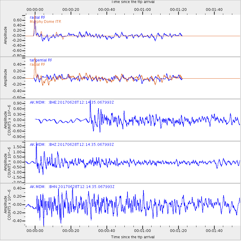
MDM Murphy Dome - Earthquake Result Viewer
*The percent match for this event was below the threshold and hence no stack was calculated.
| Earthquake location: |
Kuril Islands |
| Earthquake latitude/longitude: |
43.7/148.0 |
| Earthquake time(UTC): |
2017/06/28 (179) 12:07:30 GMT |
| Earthquake Depth: |
49 km |
| Earthquake Magnitude: |
5.4 Mww |
| Earthquake Catalog/Contributor: |
NEIC PDE/us |
|
| Network: |
AK Alaska Regional Network |
| Station: |
MDM Murphy Dome |
| Lat/Lon: |
64.96 N/148.23 W |
| Elevation: |
634 m |
|
| Distance: |
40.6 deg |
| Az: |
35.942 deg |
| Baz: |
270.297 deg |
| Ray Param: |
$rayparam |
*The percent match for this event was below the threshold and hence was not used in the summary stack. |
|
| Radial Match: |
64.757904 % |
| Radial Bump: |
400 |
| Transverse Match: |
58.429207 % |
| Transverse Bump: |
400 |
| SOD ConfigId: |
13570011 |
| Insert Time: |
2019-04-28 07:05:35.419 +0000 |
| GWidth: |
2.5 |
| Max Bumps: |
400 |
| Tol: |
0.001 |
|
Signal To Noise
| Channel | StoN | STA | LTA |
| AK:MDM: :BHZ:20170628T12:14:35.067993Z | 13.200057 | 6.1163917E-7 | 4.6336098E-8 |
| AK:MDM: :BHN:20170628T12:14:35.067993Z | 3.282238 | 1.7728921E-7 | 5.4014734E-8 |
| AK:MDM: :BHE:20170628T12:14:35.067993Z | 4.6251626 | 3.1805925E-7 | 6.876715E-8 |
| Arrivals |
| Ps | |
| PpPs | |
| PsPs/PpSs | |


