You are here: Home > Network List > AV - Alaska Volcano Observatory Stations List
> Station SPCR Ckakachatna River, Mount Spurr, Alaska > Earthquake Result Viewer
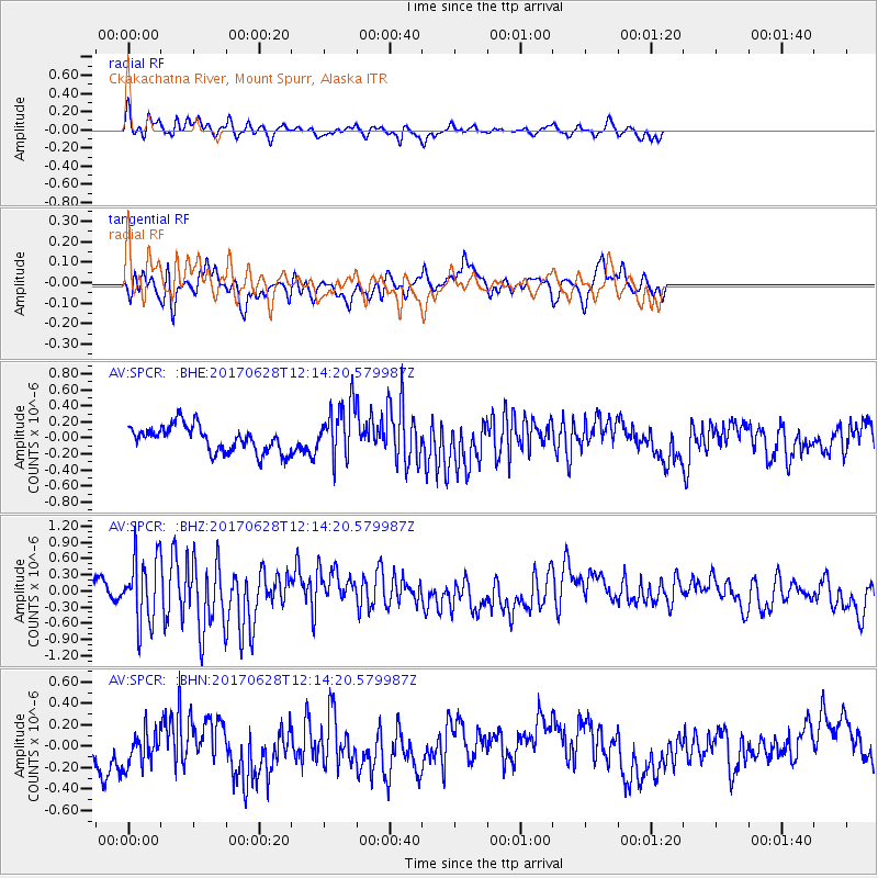
SPCR Ckakachatna River, Mount Spurr, Alaska - Earthquake Result Viewer
*The percent match for this event was below the threshold and hence no stack was calculated.
| Earthquake location: |
Kuril Islands |
| Earthquake latitude/longitude: |
43.7/148.0 |
| Earthquake time(UTC): |
2017/06/28 (179) 12:07:30 GMT |
| Earthquake Depth: |
49 km |
| Earthquake Magnitude: |
5.4 Mww |
| Earthquake Catalog/Contributor: |
NEIC PDE/us |
|
| Network: |
AV Alaska Volcano Observatory |
| Station: |
SPCR Ckakachatna River, Mount Spurr, Alaska |
| Lat/Lon: |
61.20 N/152.21 W |
| Elevation: |
984 m |
|
| Distance: |
38.8 deg |
| Az: |
41.886 deg |
| Baz: |
271.326 deg |
| Ray Param: |
$rayparam |
*The percent match for this event was below the threshold and hence was not used in the summary stack. |
|
| Radial Match: |
57.429714 % |
| Radial Bump: |
345 |
| Transverse Match: |
47.254826 % |
| Transverse Bump: |
392 |
| SOD ConfigId: |
13570011 |
| Insert Time: |
2019-04-28 07:06:30.080 +0000 |
| GWidth: |
2.5 |
| Max Bumps: |
400 |
| Tol: |
0.001 |
|
Signal To Noise
| Channel | StoN | STA | LTA |
| AV:SPCR: :BHZ:20170628T12:14:20.579987Z | 5.3371844 | 6.210701E-7 | 1.16366614E-7 |
| AV:SPCR: :BHN:20170628T12:14:20.579987Z | 0.9832469 | 1.6729075E-7 | 1.7014113E-7 |
| AV:SPCR: :BHE:20170628T12:14:20.579987Z | 2.0706933 | 3.367989E-7 | 1.6265031E-7 |
| Arrivals |
| Ps | |
| PpPs | |
| PsPs/PpSs | |


