You are here: Home > Network List > AZ - ANZA Regional Network Stations List
> Station LVA2 AZ.LVA2 > Earthquake Result Viewer
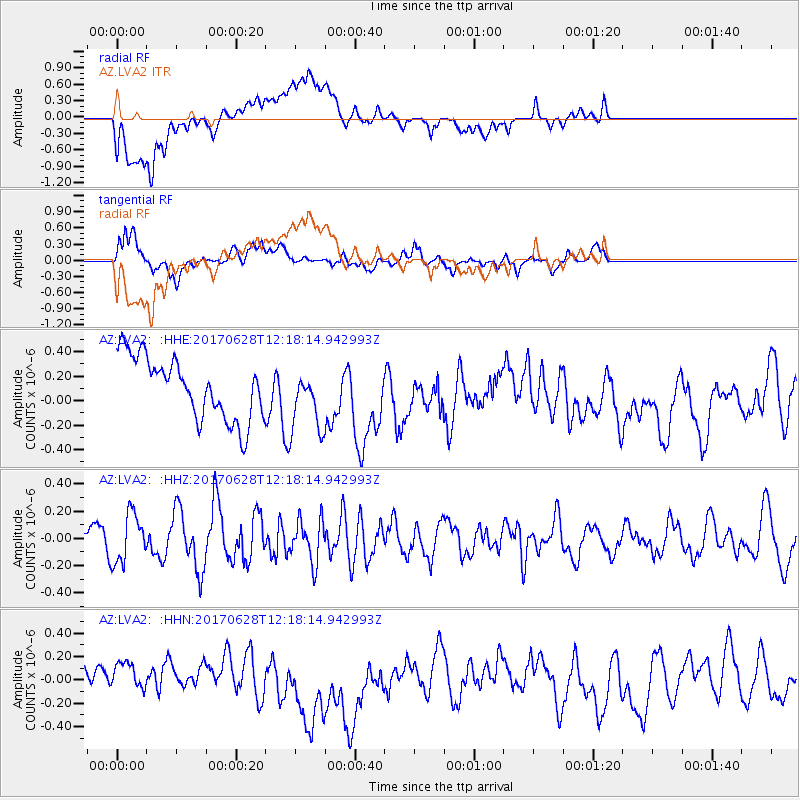
LVA2 AZ.LVA2 - Earthquake Result Viewer
*The percent match for this event was below the threshold and hence no stack was calculated.
| Earthquake location: |
Kuril Islands |
| Earthquake latitude/longitude: |
43.7/148.0 |
| Earthquake time(UTC): |
2017/06/28 (179) 12:07:30 GMT |
| Earthquake Depth: |
49 km |
| Earthquake Magnitude: |
5.4 Mww |
| Earthquake Catalog/Contributor: |
NEIC PDE/us |
|
| Network: |
AZ ANZA Regional Network |
| Station: |
LVA2 AZ.LVA2 |
| Lat/Lon: |
33.35 N/116.56 W |
| Elevation: |
1435 m |
|
| Distance: |
71.4 deg |
| Az: |
61.539 deg |
| Baz: |
310.395 deg |
| Ray Param: |
$rayparam |
*The percent match for this event was below the threshold and hence was not used in the summary stack. |
|
| Radial Match: |
49.23968 % |
| Radial Bump: |
400 |
| Transverse Match: |
67.89531 % |
| Transverse Bump: |
400 |
| SOD ConfigId: |
13570011 |
| Insert Time: |
2019-04-28 07:06:34.332 +0000 |
| GWidth: |
2.5 |
| Max Bumps: |
400 |
| Tol: |
0.001 |
|
Signal To Noise
| Channel | StoN | STA | LTA |
| AZ:LVA2: :HHZ:20170628T12:18:14.942993Z | 1.8123999 | 1.8023816E-7 | 9.944724E-8 |
| AZ:LVA2: :HHN:20170628T12:18:14.942993Z | 0.78591263 | 2.0392811E-7 | 2.5947935E-7 |
| AZ:LVA2: :HHE:20170628T12:18:14.942993Z | 1.0174694 | 2.559866E-7 | 2.5159144E-7 |
| Arrivals |
| Ps | |
| PpPs | |
| PsPs/PpSs | |


