You are here: Home > Network List > AZ - ANZA Regional Network Stations List
> Station SMER AZ.SMER > Earthquake Result Viewer
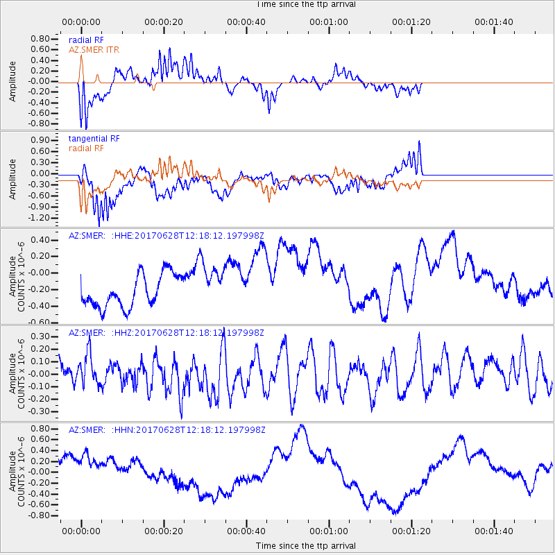
SMER AZ.SMER - Earthquake Result Viewer
*The percent match for this event was below the threshold and hence no stack was calculated.
| Earthquake location: |
Kuril Islands |
| Earthquake latitude/longitude: |
43.7/148.0 |
| Earthquake time(UTC): |
2017/06/28 (179) 12:07:30 GMT |
| Earthquake Depth: |
49 km |
| Earthquake Magnitude: |
5.4 Mww |
| Earthquake Catalog/Contributor: |
NEIC PDE/us |
|
| Network: |
AZ ANZA Regional Network |
| Station: |
SMER AZ.SMER |
| Lat/Lon: |
33.46 N/117.17 W |
| Elevation: |
355 m |
|
| Distance: |
70.9 deg |
| Az: |
61.802 deg |
| Baz: |
310.146 deg |
| Ray Param: |
$rayparam |
*The percent match for this event was below the threshold and hence was not used in the summary stack. |
|
| Radial Match: |
71.61644 % |
| Radial Bump: |
328 |
| Transverse Match: |
54.9049 % |
| Transverse Bump: |
400 |
| SOD ConfigId: |
13570011 |
| Insert Time: |
2019-04-28 07:06:35.703 +0000 |
| GWidth: |
2.5 |
| Max Bumps: |
400 |
| Tol: |
0.001 |
|
Signal To Noise
| Channel | StoN | STA | LTA |
| AZ:SMER: :HHZ:20170628T12:18:12.197998Z | 1.1520358 | 1.2599666E-7 | 1.0936869E-7 |
| AZ:SMER: :HHN:20170628T12:18:12.197998Z | 1.5441412 | 3.9062564E-7 | 2.5297277E-7 |
| AZ:SMER: :HHE:20170628T12:18:12.197998Z | 1.3917676 | 2.7058505E-7 | 1.9441828E-7 |
| Arrivals |
| Ps | |
| PpPs | |
| PsPs/PpSs | |


