You are here: Home > Network List > TA - USArray Transportable Network (new EarthScope stations) Stations List
> Station Z19A T-Link Ranch, Clifton, AZ, USA > Earthquake Result Viewer
Z19A T-Link Ranch, Clifton, AZ, USA - Earthquake Result Viewer
| Earthquake location: |
Near Coast Of Northern Chile |
| Earthquake latitude/longitude: |
-22.9/-70.4 |
| Earthquake time(UTC): |
2007/11/15 (319) 15:03:08 GMT |
| Earthquake Depth: |
27 km |
| Earthquake Magnitude: |
5.8 MB, 6.1 MW, 5.5 ML |
| Earthquake Catalog/Contributor: |
WHDF/NEIC |
|
| Network: |
TA USArray Transportable Network (new EarthScope stations) |
| Station: |
Z19A T-Link Ranch, Clifton, AZ, USA |
| Lat/Lon: |
33.29 N/109.27 W |
| Elevation: |
1397 m |
|
| Distance: |
67.0 deg |
| Az: |
325.194 deg |
| Baz: |
141.055 deg |
| Ray Param: |
0.05719393 |
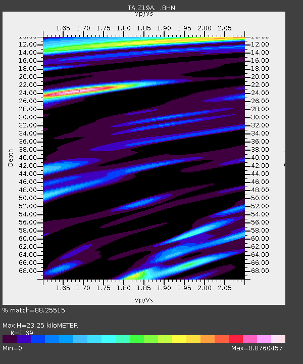
| Estimated Moho Depth: |
23.25 km |
| Estimated Crust Vp/Vs: |
1.69 |
| Assumed Crust Vp: |
6.276 km/s |
| Estimated Crust Vs: |
3.713 km/s |
| Estimated Crust Poisson's Ratio: |
0.23 |
|
| Radial Match: |
88.25515 % |
| Radial Bump: |
358 |
| Transverse Match: |
64.06418 % |
| Transverse Bump: |
400 |
| SOD ConfigId: |
2564 |
| Insert Time: |
2010-03-06 01:22:58.752 +0000 |
| GWidth: |
2.5 |
| Max Bumps: |
400 |
| Tol: |
0.001 |
|

Signal To Noise
| Channel | StoN | STA | LTA |
| TA:Z19A: :BHN:20071115T15:13:28.223022Z | 1.0414484 | 1.9553947E-7 | 1.8775725E-7 |
| TA:Z19A: :BHE:20071115T15:13:28.223022Z | 0.44730982 | 8.256533E-8 | 1.8458196E-7 |
| TA:Z19A: :BHZ:20071115T15:13:28.223022Z | 3.7716403 | 3.6968768E-7 | 9.801774E-8 |
| Arrivals |
| Ps | 2.7 SECOND |
| PpPs | 9.6 SECOND |
| PsPs/PpSs | 12 SECOND |


