You are here: Home > Network List > TA - USArray Transportable Network (new EarthScope stations) Stations List
> Station Z19A T-Link Ranch, Clifton, AZ, USA > Earthquake Result Viewer
Z19A T-Link Ranch, Clifton, AZ, USA - Earthquake Result Viewer
| Earthquake location: |
Near Coast Of Peru |
| Earthquake latitude/longitude: |
-13.4/-76.6 |
| Earthquake time(UTC): |
2007/08/15 (227) 23:40:57 GMT |
| Earthquake Depth: |
39 km |
| Earthquake Magnitude: |
6.7 MB, 7.9 MS, 8.0 MW, 7.5 ME |
| Earthquake Catalog/Contributor: |
WHDF/NEIC |
|
| Network: |
TA USArray Transportable Network (new EarthScope stations) |
| Station: |
Z19A T-Link Ranch, Clifton, AZ, USA |
| Lat/Lon: |
33.29 N/109.27 W |
| Elevation: |
1397 m |
|
| Distance: |
55.9 deg |
| Az: |
326.918 deg |
| Baz: |
140.638 deg |
| Ray Param: |
0.06440831 |
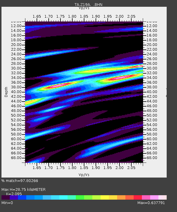
| Estimated Moho Depth: |
28.75 km |
| Estimated Crust Vp/Vs: |
2.10 |
| Assumed Crust Vp: |
6.276 km/s |
| Estimated Crust Vs: |
2.996 km/s |
| Estimated Crust Poisson's Ratio: |
0.35 |
|
| Radial Match: |
97.80266 % |
| Radial Bump: |
310 |
| Transverse Match: |
82.90973 % |
| Transverse Bump: |
400 |
| SOD ConfigId: |
2564 |
| Insert Time: |
2010-03-06 01:23:13.640 +0000 |
| GWidth: |
2.5 |
| Max Bumps: |
400 |
| Tol: |
0.001 |
|

Signal To Noise
| Channel | StoN | STA | LTA |
| TA:Z19A: :BHN:20070815T23:50:01.225022Z | 9.193291 | 9.2147746E-7 | 1.0023369E-7 |
| TA:Z19A: :BHE:20070815T23:50:01.225022Z | 8.951318 | 6.997584E-7 | 7.817379E-8 |
| TA:Z19A: :BHZ:20070815T23:50:01.225022Z | 18.973742 | 2.1461817E-6 | 1.1311326E-7 |
| Arrivals |
| Ps | 5.2 SECOND |
| PpPs | 14 SECOND |
| PsPs/PpSs | 19 SECOND |


