You are here: Home > Network List > TA - USArray Transportable Network (new EarthScope stations) Stations List
> Station Z19A T-Link Ranch, Clifton, AZ, USA > Earthquake Result Viewer
Z19A T-Link Ranch, Clifton, AZ, USA - Earthquake Result Viewer

| Earthquake location: |
Near West Coast Of Honshu, Japan |
| Earthquake latitude/longitude: |
37.5/138.4 |
| Earthquake time(UTC): |
2007/07/16 (197) 01:13:22 GMT |
| Earthquake Depth: |
12 km |
| Earthquake Magnitude: |
6.5 MB, 6.4 MS, 6.6 MW, 6.5 MW |
| Earthquake Catalog/Contributor: |
WHDF/NEIC |
|
| Network: |
TA USArray Transportable Network (new EarthScope stations) |
| Station: |
Z19A T-Link Ranch, Clifton, AZ, USA |
| Lat/Lon: |
33.29 N/109.27 W |
| Elevation: |
1397 m |
|
| Distance: |
85.5 deg |
| Az: |
51.025 deg |
| Baz: |
312.451 deg |
| Ray Param: |
0.04473526 |
| Estimated Moho Depth: |
37.0 km |
| Estimated Crust Vp/Vs: |
1.76 |
| Assumed Crust Vp: |
6.276 km/s |
| Estimated Crust Vs: |
3.556 km/s |
| Estimated Crust Poisson's Ratio: |
0.26 |
|
| Radial Match: |
95.28569 % |
| Radial Bump: |
400 |
| Transverse Match: |
91.81927 % |
| Transverse Bump: |
400 |
| SOD ConfigId: |
2564 |
| Insert Time: |
2010-03-06 01:23:18.943 +0000 |
| GWidth: |
2.5 |
| Max Bumps: |
400 |
| Tol: |
0.001 |
|
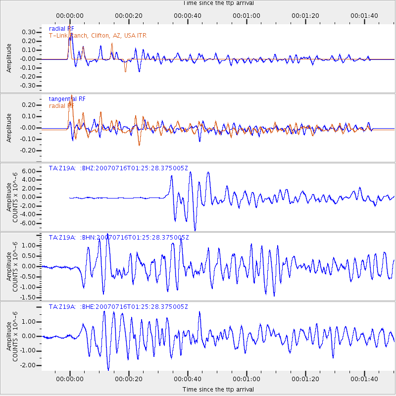
Signal To Noise
| Channel | StoN | STA | LTA |
| TA:Z19A: :BHN:20070716T01:25:28.375005Z | 10.828188 | 3.3085357E-7 | 3.0554844E-8 |
| TA:Z19A: :BHE:20070716T01:25:28.375005Z | 6.858254 | 3.2568607E-7 | 4.7488193E-8 |
| TA:Z19A: :BHZ:20070716T01:25:28.375005Z | 27.57085 | 1.7391237E-6 | 6.307835E-8 |
| Arrivals |
| Ps | 4.6 SECOND |
| PpPs | 16 SECOND |
| PsPs/PpSs | 21 SECOND |


