You are here: Home > Network List > TA - USArray Transportable Network (new EarthScope stations) Stations List
> Station Z19A T-Link Ranch, Clifton, AZ, USA > Earthquake Result Viewer
Z19A T-Link Ranch, Clifton, AZ, USA - Earthquake Result Viewer

| Earthquake location: |
Iceland |
| Earthquake latitude/longitude: |
64.0/-21.0 |
| Earthquake time(UTC): |
2008/05/29 (150) 15:46:00 GMT |
| Earthquake Depth: |
10 km |
| Earthquake Magnitude: |
6.0 MB, 6.2 MS, 6.3 MW, 6.2 MW |
| Earthquake Catalog/Contributor: |
WHDF/NEIC |
|
| Network: |
TA USArray Transportable Network (new EarthScope stations) |
| Station: |
Z19A T-Link Ranch, Clifton, AZ, USA |
| Lat/Lon: |
33.29 N/109.27 W |
| Elevation: |
1397 m |
|
| Distance: |
59.9 deg |
| Az: |
284.586 deg |
| Baz: |
30.61 deg |
| Ray Param: |
0.061892215 |
| Estimated Moho Depth: |
36.0 km |
| Estimated Crust Vp/Vs: |
1.70 |
| Assumed Crust Vp: |
6.276 km/s |
| Estimated Crust Vs: |
3.692 km/s |
| Estimated Crust Poisson's Ratio: |
0.24 |
|
| Radial Match: |
89.32624 % |
| Radial Bump: |
347 |
| Transverse Match: |
77.807785 % |
| Transverse Bump: |
400 |
| SOD ConfigId: |
2504 |
| Insert Time: |
2010-03-06 01:23:42.410 +0000 |
| GWidth: |
2.5 |
| Max Bumps: |
400 |
| Tol: |
0.001 |
|
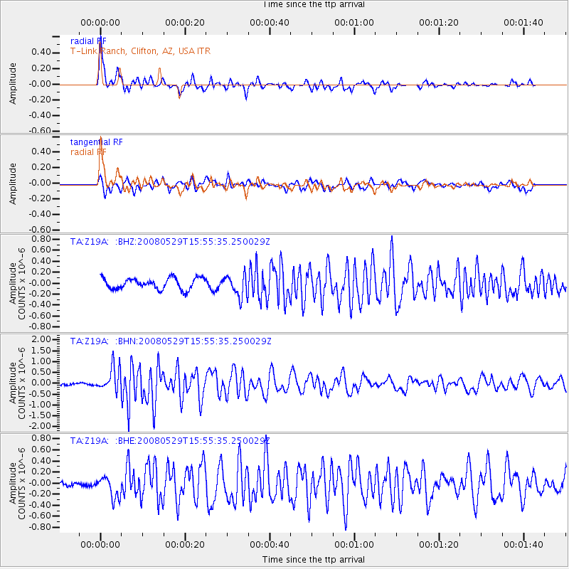
Signal To Noise
| Channel | StoN | STA | LTA |
| TA:Z19A: :BHN:20080529T15:55:35.250029Z | 12.0908575 | 5.669267E-7 | 4.6888875E-8 |
| TA:Z19A: :BHE:20080529T15:55:35.250029Z | 3.0267932 | 1.9812506E-7 | 6.545709E-8 |
| TA:Z19A: :BHZ:20080529T15:55:35.250029Z | 1.9792491 | 2.0123308E-7 | 1.01671425E-7 |
| Arrivals |
| Ps | 4.2 SECOND |
| PpPs | 15 SECOND |
| PsPs/PpSs | 19 SECOND |


