You are here: Home > Network List > TA - USArray Transportable Network (new EarthScope stations) Stations List
> Station Z19A T-Link Ranch, Clifton, AZ, USA > Earthquake Result Viewer
Z19A T-Link Ranch, Clifton, AZ, USA - Earthquake Result Viewer
| Earthquake location: |
Fiji Islands Region |
| Earthquake latitude/longitude: |
-17.3/-177.3 |
| Earthquake time(UTC): |
2008/07/19 (201) 22:39:52 GMT |
| Earthquake Depth: |
391 km |
| Earthquake Magnitude: |
5.9 MB, 6.4 MW, 6.4 MW |
| Earthquake Catalog/Contributor: |
WHDF/NEIC |
|
| Network: |
TA USArray Transportable Network (new EarthScope stations) |
| Station: |
Z19A T-Link Ranch, Clifton, AZ, USA |
| Lat/Lon: |
33.29 N/109.27 W |
| Elevation: |
1397 m |
|
| Distance: |
82.1 deg |
| Az: |
51.652 deg |
| Baz: |
243.424 deg |
| Ray Param: |
0.04605577 |
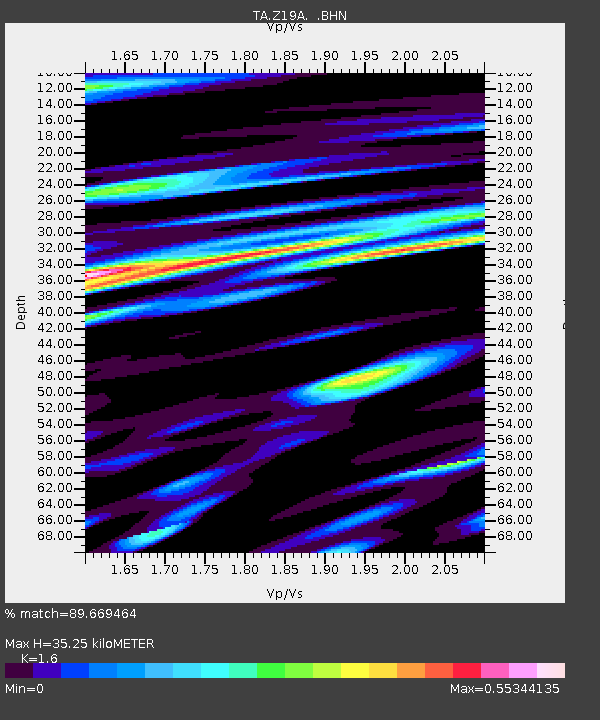
| Estimated Moho Depth: |
35.25 km |
| Estimated Crust Vp/Vs: |
1.60 |
| Assumed Crust Vp: |
6.276 km/s |
| Estimated Crust Vs: |
3.922 km/s |
| Estimated Crust Poisson's Ratio: |
0.18 |
|
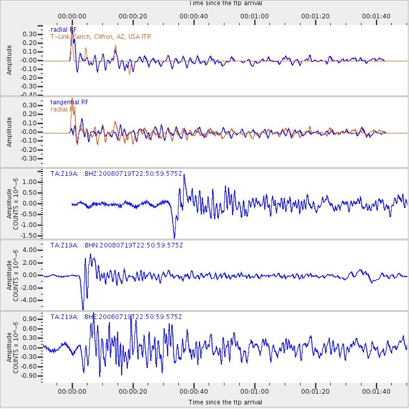
| Radial Match: |
89.669464 % |
| Radial Bump: |
400 |
| Transverse Match: |
77.67461 % |
| Transverse Bump: |
400 |
| SOD ConfigId: |
2504 |
| Insert Time: |
2010-03-06 01:23:57.151 +0000 |
| GWidth: |
2.5 |
| Max Bumps: |
400 |
| Tol: |
0.001 |
|
Signal To Noise
| Channel | StoN | STA | LTA |
| TA:Z19A: :BHN:20080719T22:50:59.575Z | 28.160892 | 1.9741117E-6 | 7.010117E-8 |
| TA:Z19A: :BHE:20080719T22:50:59.575Z | 2.748267 | 2.6119432E-7 | 9.5039645E-8 |
| TA:Z19A: :BHZ:20080719T22:50:59.575Z | 8.453681 | 5.857014E-7 | 6.9283594E-8 |
| Arrivals |
| Ps | 3.5 SECOND |
| PpPs | 14 SECOND |
| PsPs/PpSs | 18 SECOND |


