You are here: Home > Network List > TA - USArray Transportable Network (new EarthScope stations) Stations List
> Station Z19A T-Link Ranch, Clifton, AZ, USA > Earthquake Result Viewer
Z19A T-Link Ranch, Clifton, AZ, USA - Earthquake Result Viewer
| Earthquake location: |
Easter Island Region |
| Earthquake latitude/longitude: |
-28.5/-112.8 |
| Earthquake time(UTC): |
2008/08/19 (232) 10:58:00 GMT |
| Earthquake Depth: |
9.0 km |
| Earthquake Magnitude: |
5.5 MB, 5.3 MS, 5.7 MW, 5.7 MW |
| Earthquake Catalog/Contributor: |
WHDF/NEIC |
|
| Network: |
TA USArray Transportable Network (new EarthScope stations) |
| Station: |
Z19A T-Link Ranch, Clifton, AZ, USA |
| Lat/Lon: |
33.29 N/109.27 W |
| Elevation: |
1397 m |
|
| Distance: |
61.6 deg |
| Az: |
3.405 deg |
| Baz: |
183.577 deg |
| Ray Param: |
0.060777035 |
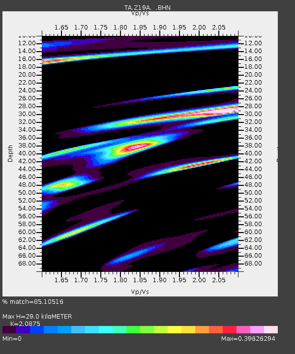
| Estimated Moho Depth: |
29.0 km |
| Estimated Crust Vp/Vs: |
2.09 |
| Assumed Crust Vp: |
6.276 km/s |
| Estimated Crust Vs: |
3.006 km/s |
| Estimated Crust Poisson's Ratio: |
0.35 |
|
| Radial Match: |
85.10516 % |
| Radial Bump: |
324 |
| Transverse Match: |
67.9137 % |
| Transverse Bump: |
309 |
| SOD ConfigId: |
2504 |
| Insert Time: |
2010-03-06 01:24:02.710 +0000 |
| GWidth: |
2.5 |
| Max Bumps: |
400 |
| Tol: |
0.001 |
|

Signal To Noise
| Channel | StoN | STA | LTA |
| TA:Z19A: :BHN:20080819T11:07:46.725024Z | 8.820471 | 5.973755E-7 | 6.772604E-8 |
| TA:Z19A: :BHE:20080819T11:07:46.725024Z | 5.4331503 | 2.4562152E-7 | 4.520794E-8 |
| TA:Z19A: :BHZ:20080819T11:07:46.725024Z | 1.4429609 | 9.767928E-8 | 6.769365E-8 |
| Arrivals |
| Ps | 5.2 SECOND |
| PpPs | 14 SECOND |
| PsPs/PpSs | 19 SECOND |


