You are here: Home > Network List > TA - USArray Transportable Network (new EarthScope stations) Stations List
> Station E22K Anaktuvuk Pass, AK, USA > Earthquake Result Viewer
E22K Anaktuvuk Pass, AK, USA - Earthquake Result Viewer
| Earthquake location: |
Kuril Islands |
| Earthquake latitude/longitude: |
43.7/148.0 |
| Earthquake time(UTC): |
2017/06/28 (179) 12:07:30 GMT |
| Earthquake Depth: |
49 km |
| Earthquake Magnitude: |
5.4 Mww |
| Earthquake Catalog/Contributor: |
NEIC PDE/us |
|
| Network: |
TA USArray Transportable Network (new EarthScope stations) |
| Station: |
E22K Anaktuvuk Pass, AK, USA |
| Lat/Lon: |
68.13 N/151.81 W |
| Elevation: |
772 m |
|
| Distance: |
39.3 deg |
| Az: |
30.856 deg |
| Baz: |
263.111 deg |
| Ray Param: |
0.07491822 |
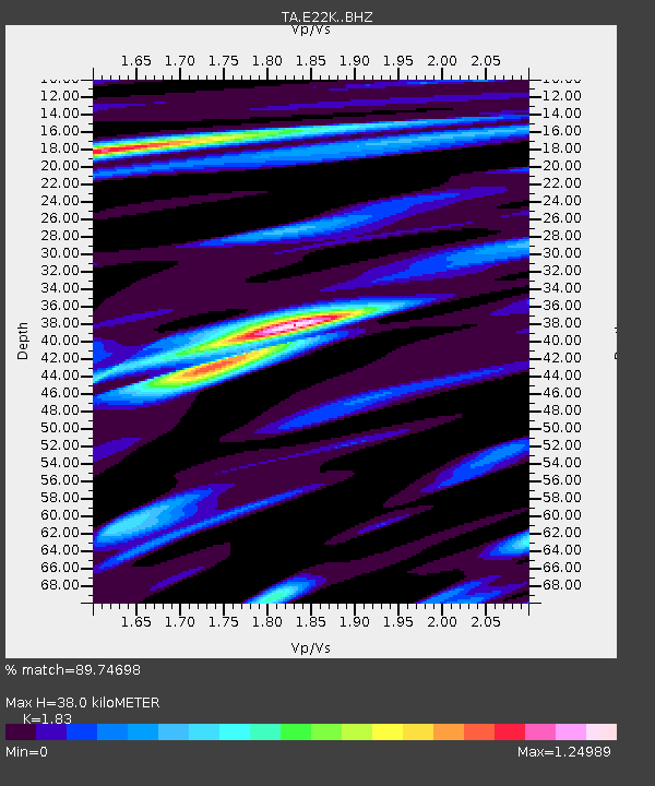
| Estimated Moho Depth: |
38.0 km |
| Estimated Crust Vp/Vs: |
1.83 |
| Assumed Crust Vp: |
6.221 km/s |
| Estimated Crust Vs: |
3.399 km/s |
| Estimated Crust Poisson's Ratio: |
0.29 |
|
| Radial Match: |
89.74698 % |
| Radial Bump: |
400 |
| Transverse Match: |
87.02884 % |
| Transverse Bump: |
400 |
| SOD ConfigId: |
13570011 |
| Insert Time: |
2019-04-28 07:12:53.414 +0000 |
| GWidth: |
2.5 |
| Max Bumps: |
400 |
| Tol: |
0.001 |
|

Signal To Noise
| Channel | StoN | STA | LTA |
| TA:E22K: :BHZ:20170628T12:14:24.674988Z | 37.01701 | 1.8120277E-6 | 4.8951215E-8 |
| TA:E22K: :BHN:20170628T12:14:24.674988Z | 10.89474 | 5.31092E-7 | 4.8747562E-8 |
| TA:E22K: :BHE:20170628T12:14:24.674988Z | 31.441647 | 9.063311E-7 | 2.8825813E-8 |
| Arrivals |
| Ps | 5.4 SECOND |
| PpPs | 16 SECOND |
| PsPs/PpSs | 22 SECOND |


